Villamejil geodata
Villamejil (Castille and León) is a seat of a third-order administrative division; located in Spain in Europe/Madrid (GMT+2) time zone. With population of 862 people, there are 3116 cities with bigger population in this country. Compared to other cities in Spain, 88.5% of cities are located further ↓South; 86.3% of cities are located further →East and 81.4% of cities have lower elevation than Villamejil. Note1
Administrative division(s):
- Level 1: Castille and León
- Level 2: Provincia de León
- Level 3: Villamejil


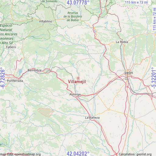
Villamejil GPS coordinates[2]
42° 33' 43.38" North, 6° 1' 30.504" West
| Map corner | latitude | longitude |
|---|---|---|
| Upper-left | 43.07778°, | -6.72826° |
| Center: | 42.56205°, | -6.02514° |
| Lower-right: | 42.04202°, | -5.32201° |
| Map W x H: | 115.2×115.2 km | = 71.6×71.6mi |
| max Lat: | 43.74134° ⇑11.5% North |
| Villamejil: | 42.56205° |
| min Lat: | ⇓88.5% South 27.64134° |
| min Long | Villamejil | max Long |
| -18.00367° | -6.02514° | 4.2899° |
| W 13.7%⇐ | ⇒86.3% E |
Elevation
Elevation of Villamejil is 911 m = 2989 ft, and this is 313 m = 1027 ft above average elevation for this country.
| Max E: |
1682 m = 5518 ft | 18.6% |
| Villamejil | 911 m 2989 ft | |
| Avg. | 598 m = 1962 ft | |
Min E: |
0 m = 0 ft | 81.4% |
See also: Spain elevation on elevation.city.
Geographical zone
Villamejil is located in North temperate zone (between Tropic of Cancer and the Arctic Circle). Distance of this Northern Tropic circle is 2126.5 km =1321.3 mi to South.| Distance of | km | miles | from Villamejil |
|---|---|---|---|
| North Pole | 5274.6 | 3277.5 | to North |
| Arctic Circle | 2668.7 | 1658.3 | to North |
| Tropic Cancer | 2126.5 | 1321.3 | to South |
| Equator | 4732.5 | 2940.6 | to South |


Nearby cities:
15 places around Villamejil: (largest is in red/bold)
• Astorga
11.8 km =7.3 mi,  192°
192°
• Benavides
12.5 km =7.8 mi,  120°
120°
• Brazuelo
13 km =8.1 mi,  236°
236°
• Carrizo de la Ribera
16.3 km =10.1 mi,  81°
81°
• Hospital de Órbigo
15.8 km =9.8 mi,  133°
133°
• Magaz de Cepeda
4.6 km =2.9 mi, 236°
• Quintana del Castillo
11.1 km =6.9 mi,  349°
349°
• San Justo de la Vega
11.7 km =7.3 mi,  177°
177°
• Santa Marina del Rey
14.5 km =9 mi,  111°
111°
• Turcia
12.4 km =7.7 mi,  104°
104°
• Val de San Lorenzo
17.9 km =11.1 mi,  206°
206°
• Villagatón
13.8 km =8.6 mi,  305°
305°
• Villaobispo de Otero
7.3 km =4.5 mi,  201°
201°
• Villarejo de Órbigo
16.3 km =10.1 mi,  142°
142°
• Villares de Órbigo
14 km =8.7 mi, 137°
Sources, notices
• [Note1] Compared only with cities in Spain existing in our database
• [Src1] Map data: © OpenStreetMap contributors (CC-BY-SA)
• [Src2] Other city data from geonames.org with taken over terms of usage.
• [Src3] Geographical zone / Annual Mean Temperature by Robert A. Rohde @ Wikipedia
