Villagatón geodata
Villagatón (Castille and León) is a seat of a third-order administrative division; located in Spain in Europe/Madrid (GMT+2) time zone. With population of 701 people, there are 3404 cities with bigger population in this country. Compared to other cities in Spain, 90.4% of cities are located further ↓South; 88.1% of cities are located further →East and 89% of cities have lower elevation than Villagatón. Note1
Administrative division(s):
- Level 1: Castille and León
- Level 2: Provincia de León
- Level 3: Villagatón


Villagatón GPS coordinates[2]
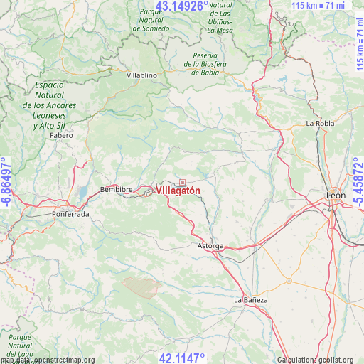
42° 38' 2.868" North, 6° 9' 42.624" West
| Map corner | latitude | longitude |
|---|---|---|
| Upper-left | 43.14926°, | -6.86497° |
| Center: | 42.63413°, | -6.16184° |
| Lower-right: | 42.1147°, | -5.45872° |
| Map W x H: | 115×115 km | = 71.5×71.5mi |
| max Lat: | 43.74134° ⇑9.6% North |
| Villagatón: | 42.63413° |
| min Lat: | ⇓90.4% South 27.64134° |
| min Long | Villagatón | max Long |
| -18.00367° | -6.16184° | 4.2899° |
| W 11.9%⇐ | ⇒88.1% E |
Elevation
Elevation of Villagatón is 1014 m = 3327 ft, and this is 416 m = 1365 ft above average elevation for this country.
| Max E: |
1682 m = 5518 ft | 11% |
| Villagatón | 1014 m 3327 ft | |
| Avg. | 598 m = 1962 ft | |
Min E: |
0 m = 0 ft | 89% |
See also: Spain elevation on elevation.city.
Geographical zone
Villagatón is located in North temperate zone (between Tropic of Cancer and the Arctic Circle). Distance of this Northern Tropic circle is 2134.6 km =1326.4 mi to South.| Distance of | km | miles | from Villagatón |
|---|---|---|---|
| North Pole | 5266.6 | 3272.5 | to North |
| Arctic Circle | 2660.7 | 1653.3 | to North |
| Tropic Cancer | 2134.6 | 1326.4 | to South |
| Equator | 4740.5 | 2945.6 | to South |


Nearby cities:
15 places around Villagatón: (largest is in red/bold)
• Astorga
21.3 km =13.2 mi,  156°
156°
• Bembibre
20.8 km =12.9 mi,  264°
264°
• Brazuelo
15.2 km =9.4 mi,  178°
178°
• Folgoso de la Ribera
13 km =8.1 mi,  276°
276°
• Igüeña
14.1 km =8.8 mi,  318°
318°
• Magaz de Cepeda
12.8 km =8 mi,  144°
144°
• Murias de Paredes
24.2 km =15 mi,  354°
354°
• Quintana del Castillo
9.6 km =6 mi,  72°
72°
• San Justo de la Vega
22.9 km =14.2 mi,  149°
149°
• Santa Colomba de Somoza
22.1 km =13.7 mi,  197°
197°
• Torre del Bierzo
17 km =10.6 mi, 260°
• Val de San Lorenzo
24.2 km =15 mi,  172°
172°
• Valdesamario
19.8 km =12.3 mi,  60°
60°
• Villamejil
13.8 km =8.6 mi,  125°
125°
• Villaobispo de Otero
17.1 km =10.6 mi, 150°
Sources, notices
• [Note1] Compared only with cities in Spain existing in our database
• [Src1] Map data: © OpenStreetMap contributors (CC-BY-SA)
• [Src2] Other city data from geonames.org with taken over terms of usage.
• [Src3] Geographical zone / Annual Mean Temperature by Robert A. Rohde @ Wikipedia
