Brazuelo geodata
Brazuelo (Castille and León) is a seat of a third-order administrative division; located in Spain in Europe/Madrid (GMT+2) time zone. With population of 328 people, there are 4392 cities with bigger population in this country. Compared to other cities in Spain, 87.1% of cities are located further ↓South; 88% of cities are located further →East and 86.4% of cities have lower elevation than Brazuelo. Note1


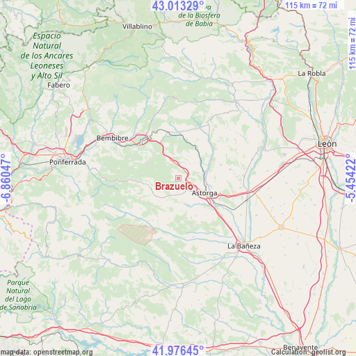
Brazuelo GPS coordinates[2]
42° 29' 49.272" North, 6° 9' 26.424" West
| Map corner | latitude | longitude |
|---|---|---|
| Upper-left | 43.01329°, | -6.86047° |
| Center: | 42.49702°, | -6.15734° |
| Lower-right: | 41.97645°, | -5.45422° |
| Map W x H: | 115.3×115.3 km | = 71.6×71.6mi |
| max Lat: | 43.74134° ⇑12.9% North |
| Brazuelo: | 42.49702° |
| min Lat: | ⇓87.1% South 27.64134° |
| min Long | Brazuelo | max Long |
| -18.00367° | -6.15734° | 4.2899° |
| W 12%⇐ | ⇒88% E |
Elevation
Elevation of Brazuelo is 970 m = 3182 ft, and this is 372 m = 1220 ft above average elevation for this country.
| Max E: |
1682 m = 5518 ft | 13.6% |
| Brazuelo | 970 m 3182 ft | |
| Avg. | 598 m = 1962 ft | |
Min E: |
0 m = 0 ft | 86.4% |
See also: Spain elevation on elevation.city.
Geographical zone
Brazuelo is located in North temperate zone (between Tropic of Cancer and the Arctic Circle). Distance of this Northern Tropic circle is 2119.3 km =1316.9 mi to South.| Distance of | km | miles | from Brazuelo |
|---|---|---|---|
| North Pole | 5281.8 | 3282 | to North |
| Arctic Circle | 2675.9 | 1662.7 | to North |
| Tropic Cancer | 2119.3 | 1316.9 | to South |
| Equator | 4725.2 | 2936.1 | to South |


Nearby cities:
15 places around Brazuelo: (largest is in red/bold)
• Astorga
9.3 km =5.8 mi,  117°
117°
• Castrillo de la Valduerna
19.3 km =12 mi,  174°
174°
• Destriana
19.5 km =12.1 mi,  164°
164°
• Luyego
15.8 km =9.8 mi,  203°
203°
• Magaz de Cepeda
8.5 km =5.3 mi,  55°
55°
• Quintana del Castillo
20.1 km =12.5 mi,  25°
25°
• Riego de la Vega
18.6 km =11.6 mi,  129°
129°
• San Justo de la Vega
12.2 km =7.6 mi,  111°
111°
• Santa Colomba de Somoza
9.2 km =5.7 mi,  230°
230°
• Santiago Millas
13.3 km =8.3 mi, 161°
• Val de San Lorenzo
9.2 km =5.7 mi, 162°
• Valderrey
16 km =9.9 mi,  135°
135°
• Villagatón
15.2 km =9.4 mi,  358°
358°
• Villamejil
13 km =8.1 mi, 56°
• Villaobispo de Otero
8.1 km =5 mi,  87°
87°
Sources, notices
• [Note1] Compared only with cities in Spain existing in our database
• [Src1] Map data: © OpenStreetMap contributors (CC-BY-SA)
• [Src2] Other city data from geonames.org with taken over terms of usage.
• [Src3] Geographical zone / Annual Mean Temperature by Robert A. Rohde @ Wikipedia
