Matilla la Seca geodata
Matilla la Seca (Castille and León) is a seat of a third-order administrative division; located in Spain in Europe/Madrid (GMT+2) time zone. With population of 60 people, there are 6350 cities with bigger population in this country. Compared to other cities in Spain, 62.9% of cities are located further ↓South; 78.7% of cities are located further →East and 59.3% of cities have lower elevation than Matilla la Seca. Note1
Administrative division(s):
- Level 1: Castille and León
- Level 2: Provincia de Zamora
- Level 3: Matilla la Seca


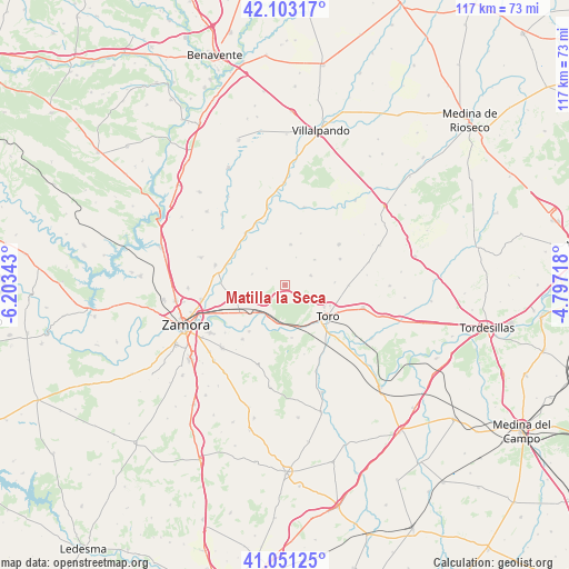
Matilla la Seca GPS coordinates[2]
41° 34' 45.66" North, 5° 30' 1.08" West
| Map corner | latitude | longitude |
|---|---|---|
| Upper-left | 42.10317°, | -6.20343° |
| Center: | 41.57935°, | -5.5003° |
| Lower-right: | 41.05125°, | -4.79718° |
| Map W x H: | 117×117 km | = 72.7×72.7mi |
| max Lat: | 43.74134° ⇑37.1% North |
| Matilla la Seca: | 41.57935° |
| min Lat: | ⇓62.9% South 27.64134° |
| min Long | Matilla la Seca | max Long |
| -18.00367° | -5.5003° | 4.2899° |
| W 21.3%⇐ | ⇒78.7% E |
Elevation
Elevation of Matilla la Seca is 740 m = 2428 ft, and this is 142 m = 466 ft above average elevation for this country.
| Max E: |
1682 m = 5518 ft | 40.7% |
| Matilla la Seca | 740 m 2428 ft | |
| Avg. | 598 m = 1962 ft | |
Min E: |
0 m = 0 ft | 59.3% |
See also: Spain elevation on elevation.city.
Geographical zone
Matilla la Seca is located in North temperate zone (between Tropic of Cancer and the Arctic Circle). Distance of this Northern Tropic circle is 2017.3 km =1253.5 mi to South.| Distance of | km | miles | from Matilla la Seca |
|---|---|---|---|
| North Pole | 5383.9 | 3345.4 | to North |
| Arctic Circle | 2778 | 1726.2 | to North |
| Tropic Cancer | 2017.3 | 1253.5 | to South |
| Equator | 4623.2 | 2872.7 | to South |


Nearby cities:
15 places around Matilla la Seca: (largest is in red/bold)
• Abezames
8.1 km =5 mi,  49°
49°
• Algodre
8.8 km =5.5 mi,  260°
260°
• Benegiles
12.4 km =7.7 mi,  295°
295°
• Bustillo del Oro
11.1 km =6.9 mi,  16°
16°
• Coreses
10.8 km =6.7 mi,  251°
251°
• Fresno de la Ribera
7.8 km =4.8 mi,  224°
224°
• Fuentesecas
6.2 km =3.9 mi, 21°
• Gallegos del Pan
7.1 km =4.4 mi,  288°
288°
• Malva
8.5 km =5.3 mi,  7°
7°
• Peleagonzalo
10.9 km =6.8 mi,  172°
172°
• Pozoantiguo
5.7 km =3.5 mi,  69°
69°
• Toro
10.7 km =6.6 mi,  125°
125°
• Villalazán
12 km =7.5 mi, 217°
• Villalube
5.1 km =3.2 mi,  312°
312°
• Villardondiego
10.3 km =6.4 mi,  86°
86°
Sources, notices
• [Note1] Compared only with cities in Spain existing in our database
• [Src1] Map data: © OpenStreetMap contributors (CC-BY-SA)
• [Src2] Other city data from geonames.org with taken over terms of usage.
• [Src3] Geographical zone / Annual Mean Temperature by Robert A. Rohde @ Wikipedia
