Villadangos del Páramo geodata
Villadangos del Páramo (Castille and León) is a seat of a third-order administrative division; located in Spain in Europe/Madrid (GMT+2) time zone. With population of 1,035 people, there are 2894 cities with bigger population in this country. Compared to other cities in Spain, 87.6% of cities are located further ↓South; 82.8% of cities are located further →East and 79.9% of cities have lower elevation than Villadangos del Páramo. Note1
Administrative division(s):
- Level 1: Castille and León
- Level 2: Provincia de León
- Level 3: Villadangos del Páramo
Current local time in Villadangos del Páramo:
10:49 PM, ThursdayDifference from your time zone: hours


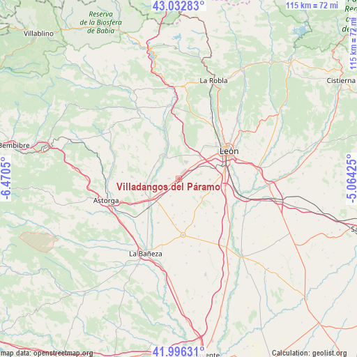
Villadangos del Páramo GPS coordinates[2]
42° 31' 0.192" North, 5° 46' 2.532" West
| Map corner | latitude | longitude |
|---|---|---|
| Upper-left | 43.03283°, | -6.4705° |
| Center: | 42.51672°, | -5.76737° |
| Lower-right: | 41.99631°, | -5.06425° |
| Map W x H: | 115.3×115.2 km | = 71.6×71.6mi |
| max Lat: | 43.74134° ⇑12.4% North |
| Villadangos del Páramo: | 42.51672° |
| min Lat: | ⇓87.6% South 27.64134° |
| min Long | Villadangos del | max Long |
| -18.00367° | -5.76737° | 4.2899° |
| W 17.2%⇐ | ⇒82.8% E |
Elevation
Elevation of Villadangos del Páramo is 896 m = 2940 ft, and this is 298 m = 978 ft above average elevation for this country.
| Max E: |
1682 m = 5518 ft | 20.1% |
| Villadangos del Páramo | 896 m 2940 ft | |
| Avg. | 598 m = 1962 ft | |
Min E: |
0 m = 0 ft | 79.9% |
See also: Spain elevation on elevation.city.
Geographical zone
Villadangos del Páramo is located in North temperate zone (between Tropic of Cancer and the Arctic Circle). Distance of this Northern Tropic circle is 2121.5 km =1318.2 mi to South.| Distance of | km | miles | from Villadangos del Páramo |
|---|---|---|---|
| North Pole | 5279.6 | 3280.6 | to North |
| Arctic Circle | 2673.8 | 1661.4 | to North |
| Tropic Cancer | 2121.5 | 1318.2 | to South |
| Equator | 4727.4 | 2937.5 | to South |


Nearby cities:
15 places around Villadangos del Páramo: (largest is in red/bold)
• Benavides
10.5 km =6.5 mi,  262°
262°
• Bercianos del Páramo
15.9 km =9.9 mi,  162°
162°
• Bustillo del Páramo
8.6 km =5.3 mi,  193°
193°
• Carrizo de la Ribera
9 km =5.6 mi,  326°
326°
• Chozas de Abajo
6.7 km =4.2 mi,  99°
99°
• Cimanes del Tejar
11.7 km =7.3 mi,  344°
344°
• Hospital de Órbigo
11.4 km =7.1 mi,  238°
238°
• Llamas de la Ribera
14 km =8.7 mi, 340°
• Onzonilla
15.2 km =9.4 mi,  86°
86°
• San Pedro Bercianos
14.6 km =9.1 mi, 162°
• Santa Marina del Rey
7.7 km =4.8 mi,  267°
267°
• Turcia
9.3 km =5.8 mi,  282°
282°
• Valverde de la Virgen
8.9 km =5.5 mi,  49°
49°
• Villarejo de Órbigo
13.8 km =8.6 mi,  234°
234°
• Villares de Órbigo
12.8 km =8 mi,  245°
245°
Sources, notices
• [Note1] Compared only with cities in Spain existing in our database
• [Src1] Map data: © OpenStreetMap contributors (CC-BY-SA)
• [Src2] Other city data from geonames.org with taken over terms of usage.
• [Src3] Geographical zone / Annual Mean Temperature by Robert A. Rohde @ Wikipedia
