Villabrágima geodata
Villabrágima (Castille and León) is a seat of a third-order administrative division; located in Spain in Europe/Madrid (GMT+2) time zone. With population of 1,176 people, there are 2747 cities with bigger population in this country. Compared to other cities in Spain, 69.1% of cities are located further ↓South; 74% of cities are located further →East and 58.1% of cities have lower elevation than Villabrágima. Note1
Administrative division(s):
- Level 1: Castille and León
- Level 2: Provincia de Valladolid
- Level 3: Villabrágima


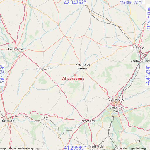
Villabrágima GPS coordinates[2]
41° 49' 18.408" North, 5° 6' 55.656" West
| Map corner | latitude | longitude |
|---|---|---|
| Upper-left | 42.34362°, | -5.81859° |
| Center: | 41.82178°, | -5.11546° |
| Lower-right: | 41.29565°, | -4.41234° |
| Map W x H: | 116.5×116.5 km | = 72.4×72.4mi |
| max Lat: | 43.74134° ⇑30.9% North |
| Villabrágima: | 41.82178° |
| min Lat: | ⇓69.1% South 27.64134° |
| min Long | Villabrágima | max Long |
| -18.00367° | -5.11546° | 4.2899° |
| W 26%⇐ | ⇒74% E |
Elevation
Elevation of Villabrágima is 730 m = 2395 ft, and this is 132 m = 433 ft above average elevation for this country.
| Max E: |
1682 m = 5518 ft | 41.9% |
| Villabrágima | 730 m 2395 ft | |
| Avg. | 598 m = 1962 ft | |
Min E: |
0 m = 0 ft | 58.1% |
See also: Spain elevation on elevation.city.
Geographical zone
Villabrágima is located in North temperate zone (between Tropic of Cancer and the Arctic Circle). Distance of this Northern Tropic circle is 2044.2 km =1270.2 mi to South.| Distance of | km | miles | from Villabrágima |
|---|---|---|---|
| North Pole | 5356.9 | 3328.6 | to North |
| Arctic Circle | 2751 | 1709.4 | to North |
| Tropic Cancer | 2044.2 | 1270.2 | to South |
| Equator | 4650.1 | 2889.4 | to South |


Nearby cities:
15 places around Villabrágima: (largest is in red/bold)
• Berrueces
13.9 km =8.6 mi,  6°
6°
• Cabreros del Monte
13.2 km =8.2 mi,  283°
283°
• Castromonte
8.3 km =5.2 mi,  130°
130°
• Medina de Ríoseco
9 km =5.6 mi,  40°
40°
• Morales de Campos
6.4 km =4 mi,  312°
312°
• Palazuelo de Vedija
12.2 km =7.6 mi,  348°
348°
• Pozuelo de la Orden
11.9 km =7.4 mi,  269°
269°
• Tordehumos
3.6 km =2.2 mi,  258°
258°
• Urueña
12.8 km =8 mi,  214°
214°
• Valdenebro de los Valles
12.7 km =7.9 mi,  72°
72°
• Valverde de Campos
6.7 km =4.2 mi,  77°
77°
• Villafrechós
11.6 km =7.2 mi, 312°
• Villagarcía de Campos
7.9 km =4.9 mi,  234°
234°
• Villanueva de San Mancio
14.6 km =9.1 mi, 35°
• Villanueva de los Caballeros
13 km =8.1 mi,  237°
237°
Sources, notices
• [Note1] Compared only with cities in Spain existing in our database
• [Src1] Map data: © OpenStreetMap contributors (CC-BY-SA)
• [Src2] Other city data from geonames.org with taken over terms of usage.
• [Src3] Geographical zone / Annual Mean Temperature by Robert A. Rohde @ Wikipedia
