Esponellà geodata
Esponellà (Catalonia) is a seat of a third-order administrative division; located in Spain in Europe/Madrid (GMT+2) time zone. With population of 434 people, there are 4044 cities with bigger population in this country. Compared to other cities in Spain, 78.3% of cities are located further ↓South; 97.6% of cities are located further ←West and 79.7% of cities have higher elevation than Esponellà. Note1


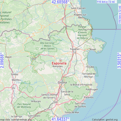
Esponellà GPS coordinates[2]
42° 10' 0.012" North, 2° 48' 0" East
| Map corner | latitude | longitude |
|---|---|---|
| Upper-left | 42.68568°, | 2.09688° |
| Center: | 42.16667°, | 2.8° |
| Lower-right: | 41.64337°, | 3.50313° |
| Map W x H: | 115.9×115.9 km | = 72×72mi |
| max Lat: | 43.74134° ⇑21.7% North |
| Esponellà: | 42.16667° |
| min Lat: | ⇓78.3% South 27.64134° |
| min Long | Esponellà | max Long |
| -18.00367° | 2.8° | 4.2899° |
| W 97.6%⇐ | ⇒2.4% E |
Elevation
Elevation of Esponellà is 226 m = 741 ft, and this is 372 m = 1220 ft below average elevation for this country.
| Max E: |
1682 m = 5518 ft | 79.7% |
| Avg. | 598 m = 1962 ft | |
| Esponellà | 226 m = 741 ft | |
Min E: |
0 m = 0 ft | 20.3% |
See also: Spain elevation on elevation.city.
Geographical zone
Esponellà is located in North temperate zone (between Tropic of Cancer and the Arctic Circle). Distance of this Northern Tropic circle is 2082.6 km =1294.1 mi to South.| Distance of | km | miles | from Esponellà |
|---|---|---|---|
| North Pole | 5318.6 | 3304.8 | to North |
| Arctic Circle | 2712.7 | 1685.6 | to North |
| Tropic Cancer | 2082.6 | 1294.1 | to South |
| Equator | 4688.5 | 2913.3 | to South |


Nearby cities:
15 places around Esponellà: (largest is in red/bold)
• Banyoles
6.2 km =3.9 mi,  206°
206°
• Besalú
9 km =5.6 mi,  293°
293°
• Bàscara
9.1 km =5.7 mi,  94°
94°
• Cabanelles
7.3 km =4.5 mi,  13°
13°
• Camós
9.3 km =5.8 mi,  199°
199°
• Cornellà del Terri
9.4 km =5.8 mi,  171°
171°
• Crespià
1.9 km =1.2 mi,  0°
0°
• Fontcoberta
3.7 km =2.3 mi,  180°
180°
• Lladó
9.1 km =5.7 mi, 7°
• Navata
8.1 km =5 mi,  38°
38°
• Ordis
10.5 km =6.5 mi,  56°
56°
• Pontós
9.9 km =6.2 mi,  77°
77°
• Porqueres
7.4 km =4.6 mi,  221°
221°
• Sant Miquel de Campmajor
10.3 km =6.4 mi,  248°
248°
• Vilademuls
7.9 km =4.9 mi,  113°
113°
Sources, notices
• [Note1] Compared only with cities in Spain existing in our database
• [Src1] Map data: © OpenStreetMap contributors (CC-BY-SA)
• [Src2] Other city data from geonames.org with taken over terms of usage.
• [Src3] Geographical zone / Annual Mean Temperature by Robert A. Rohde @ Wikipedia
