Vallecillo geodata
Vallecillo (Castille and León) is a seat of a third-order administrative division; located in Spain in Europe/Madrid (GMT+2) time zone. With population of 145 people, there are 5463 cities with bigger population in this country. Compared to other cities in Spain, 83.5% of cities are located further ↓South; 75.2% of cities are located further →East and 73.8% of cities have lower elevation than Vallecillo. Note1
Administrative division(s):
- Level 1: Castille and León
- Level 2: Provincia de León
- Level 3: Vallecillo


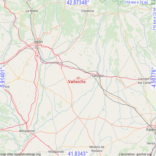
Vallecillo GPS coordinates[2]
42° 21' 21.744" North, 5° 12' 39.168" West
| Map corner | latitude | longitude |
|---|---|---|
| Upper-left | 42.87348°, | -5.91401° |
| Center: | 42.35604°, | -5.21088° |
| Lower-right: | 41.8343°, | -4.50776° |
| Map W x H: | 115.5×115.5 km | = 71.8×71.8mi |
| max Lat: | 43.74134° ⇑16.5% North |
| Vallecillo: | 42.35604° |
| min Lat: | ⇓83.5% South 27.64134° |
| min Long | Vallecillo | max Long |
| -18.00367° | -5.21088° | 4.2899° |
| W 24.8%⇐ | ⇒75.2% E |
Elevation
Elevation of Vallecillo is 842 m = 2762 ft, and this is 244 m = 801 ft above average elevation for this country.
| Max E: |
1682 m = 5518 ft | 26.2% |
| Vallecillo | 842 m 2762 ft | |
| Avg. | 598 m = 1962 ft | |
Min E: |
0 m = 0 ft | 73.8% |
See also: Spain elevation on elevation.city.
Geographical zone
Vallecillo is located in North temperate zone (between Tropic of Cancer and the Arctic Circle). Distance of this Northern Tropic circle is 2103.6 km =1307.1 mi to South.| Distance of | km | miles | from Vallecillo |
|---|---|---|---|
| North Pole | 5297.5 | 3291.7 | to North |
| Arctic Circle | 2691.6 | 1672.5 | to North |
| Tropic Cancer | 2103.6 | 1307.1 | to South |
| Equator | 4709.6 | 2926.4 | to South |


Nearby cities:
15 places around Vallecillo: (largest is in red/bold)
• Bercianos del Real Camino
6.5 km =4 mi,  57°
57°
• Calzada del Coto
11.4 km =7.1 mi,  72°
72°
• El Burgo Ranero
7.4 km =4.6 mi,  354°
354°
• Gordaliza del Pino
4.6 km =2.9 mi,  107°
107°
• Izagre
15.2 km =9.4 mi,  194°
194°
• Joarilla de las Matas
8.1 km =5 mi,  160°
160°
• Matadeón de los Oteros
13.1 km =8.1 mi,  261°
261°
• Melgar de Abajo
13.7 km =8.5 mi, 155°
• Melgar de Arriba
13.5 km =8.4 mi,  136°
136°
• Monasterio de Vega
14.2 km =8.8 mi,  170°
170°
• Sahagún
15 km =9.3 mi,  83°
83°
• Santa Cristina de Valmadrigal
8.1 km =5 mi,  268°
268°
• Valverde-Enrique
9.3 km =5.8 mi,  231°
231°
• Villamol
15.5 km =9.6 mi, 59°
• Villamoratiel de las Matas
8.7 km =5.4 mi,  302°
302°
Sources, notices
• [Note1] Compared only with cities in Spain existing in our database
• [Src1] Map data: © OpenStreetMap contributors (CC-BY-SA)
• [Src2] Other city data from geonames.org with taken over terms of usage.
• [Src3] Geographical zone / Annual Mean Temperature by Robert A. Rohde @ Wikipedia
