Villabraz geodata
Villabraz (Castille and León) is a seat of a third-order administrative division; located in Spain in Europe/Madrid (GMT+2) time zone. With population of 141 people, there are 5493 cities with bigger population in this country. Compared to other cities in Spain, 80.5% of cities are located further ↓South; 78% of cities are located further →East and 74.4% of cities have lower elevation than Villabraz. Note1
Administrative division(s):
- Level 1: Castille and León
- Level 2: Provincia de León
- Level 3: Villabraz


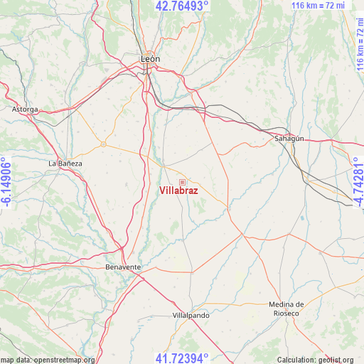
Villabraz GPS coordinates[2]
42° 14' 47.688" North, 5° 26' 45.348" West
| Map corner | latitude | longitude |
|---|---|---|
| Upper-left | 42.76493°, | -6.14906° |
| Center: | 42.24658°, | -5.44593° |
| Lower-right: | 41.72394°, | -4.74281° |
| Map W x H: | 115.7×115.7 km | = 71.9×71.9mi |
| max Lat: | 43.74134° ⇑19.5% North |
| Villabraz: | 42.24658° |
| min Lat: | ⇓80.5% South 27.64134° |
| min Long | Villabraz | max Long |
| -18.00367° | -5.44593° | 4.2899° |
| W 22%⇐ | ⇒78% E |
Elevation
Elevation of Villabraz is 847 m = 2779 ft, and this is 249 m = 817 ft above average elevation for this country.
| Max E: |
1682 m = 5518 ft | 25.6% |
| Villabraz | 847 m 2779 ft | |
| Avg. | 598 m = 1962 ft | |
Min E: |
0 m = 0 ft | 74.4% |
See also: Spain elevation on elevation.city.
Geographical zone
Villabraz is located in North temperate zone (between Tropic of Cancer and the Arctic Circle). Distance of this Northern Tropic circle is 2091.5 km =1299.6 mi to South.| Distance of | km | miles | from Villabraz |
|---|---|---|---|
| North Pole | 5309.7 | 3299.3 | to North |
| Arctic Circle | 2703.8 | 1680.1 | to North |
| Tropic Cancer | 2091.5 | 1299.6 | to South |
| Equator | 4697.4 | 2918.8 | to South |


Nearby cities:
15 places around Villabraz: (largest is in red/bold)
• Algadefe
11.8 km =7.3 mi,  255°
255°
• Campazas
12.3 km =7.6 mi,  198°
198°
• Castilfalé
3.6 km =2.2 mi,  145°
145°
• Fresno de la Vega
13.3 km =8.3 mi,  326°
326°
• Fuentes de Carbajal
7.7 km =4.8 mi,  180°
180°
• Gordoncillo
12.9 km =8 mi,  163°
163°
• Matadeón de los Oteros
12 km =7.5 mi,  32°
32°
• Pajares de los Oteros
9.6 km =6 mi,  346°
346°
• San Millán de los Caballeros
10.4 km =6.5 mi,  294°
294°
• Toral de los Guzmanes
10 km =6.2 mi,  267°
267°
• Valdemora
5.9 km =3.7 mi,  165°
165°
• Valencia de Don Juan
7.9 km =4.9 mi,  311°
311°
• Valverde-Enrique
13.6 km =8.5 mi,  61°
61°
• Villademor de la Vega
10.4 km =6.5 mi,  284°
284°
• Villamañán
14 km =8.7 mi, 306°
Sources, notices
• [Note1] Compared only with cities in Spain existing in our database
• [Src1] Map data: © OpenStreetMap contributors (CC-BY-SA)
• [Src2] Other city data from geonames.org with taken over terms of usage.
• [Src3] Geographical zone / Annual Mean Temperature by Robert A. Rohde @ Wikipedia
