Valmala geodata
Valmala (Castille and León) is a seat of a third-order administrative division; located in Spain in Europe/Madrid (GMT+2) time zone. With population of 32 people, there are 6640 cities with bigger population in this country. Compared to other cities in Spain, 81.9% of cities are located further ↓South; 50.9% of cities are located further ←West and 87.5% of cities have lower elevation than Valmala. Note1
Administrative division(s):
- Level 1: Castille and León
- Level 2: Provincia de Burgos
- Level 3: Valmala


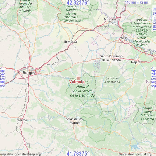
Valmala GPS coordinates[2]
42° 18' 21.24" North, 3° 15' 16.416" West
| Map corner | latitude | longitude |
|---|---|---|
| Upper-left | 42.82376°, | -3.95769° |
| Center: | 42.3059°, | -3.25456° |
| Lower-right: | 41.78375°, | -2.55144° |
| Map W x H: | 115.6×115.6 km | = 71.8×71.8mi |
| max Lat: | 43.74134° ⇑18.1% North |
| Valmala: | 42.3059° |
| min Lat: | ⇓81.9% South 27.64134° |
| min Long | Valmala | max Long |
| -18.00367° | -3.25456° | 4.2899° |
| W 50.9%⇐ | ⇒49.1% E |
Elevation
Elevation of Valmala is 989 m = 3245 ft, and this is 391 m = 1283 ft above average elevation for this country.
| Max E: |
1682 m = 5518 ft | 12.5% |
| Valmala | 989 m 3245 ft | |
| Avg. | 598 m = 1962 ft | |
Min E: |
0 m = 0 ft | 87.5% |
See also: Spain elevation on elevation.city.
Geographical zone
Valmala is located in North temperate zone (between Tropic of Cancer and the Arctic Circle). Distance of this Northern Tropic circle is 2098.1 km =1303.7 mi to South.| Distance of | km | miles | from Valmala |
|---|---|---|---|
| North Pole | 5303.1 | 3295.2 | to North |
| Arctic Circle | 2697.2 | 1676 | to North |
| Tropic Cancer | 2098.1 | 1303.7 | to South |
| Equator | 4704 | 2922.9 | to South |


Nearby cities:
15 places around Valmala: (largest is in red/bold)
• Arlanzón
16.8 km =10.4 mi,  276°
276°
• Arraya de Oca
16.9 km =10.5 mi,  315°
315°
• Belorado
13.8 km =8.6 mi,  22°
22°
• Cerratón de Juarros
16.2 km =10.1 mi, 322°
• Espinosa del Camino
11.3 km =7 mi,  349°
349°
• Fresneda de la Sierra Tirón
9.8 km =6.1 mi,  83°
83°
• Fresneña
15.5 km =9.6 mi,  39°
39°
• Pineda de la Sierra
10.6 km =6.6 mi,  199°
199°
• Pradoluengo
4.7 km =2.9 mi,  63°
63°
• Rábanos
2 km =1.2 mi, 319°
• San Vicente del Valle
8.4 km =5.2 mi,  65°
65°
• Santa Cruz del Valle Urbión
2.7 km =1.7 mi,  90°
90°
• Tosantos
12 km =7.5 mi,  4°
4°
• Valgañón
15.5 km =9.6 mi, 85°
• Villagalijo
7 km =4.3 mi,  47°
47°
Sources, notices
• [Note1] Compared only with cities in Spain existing in our database
• [Src1] Map data: © OpenStreetMap contributors (CC-BY-SA)
• [Src2] Other city data from geonames.org with taken over terms of usage.
• [Src3] Geographical zone / Annual Mean Temperature by Robert A. Rohde @ Wikipedia
