Villagalijo geodata
Villagalijo (Castille and León) is a seat of a third-order administrative division; located in Spain in Europe/Madrid (GMT+2) time zone. With population of 85 people, there are 6086 cities with bigger population in this country. Compared to other cities in Spain, 83.3% of cities are located further ↓South; 51.7% of cities are located further ←West and 80.2% of cities have lower elevation than Villagalijo. Note1
Administrative division(s):
- Level 1: Castille and León
- Level 2: Provincia de Burgos
- Level 3: Villagalijo


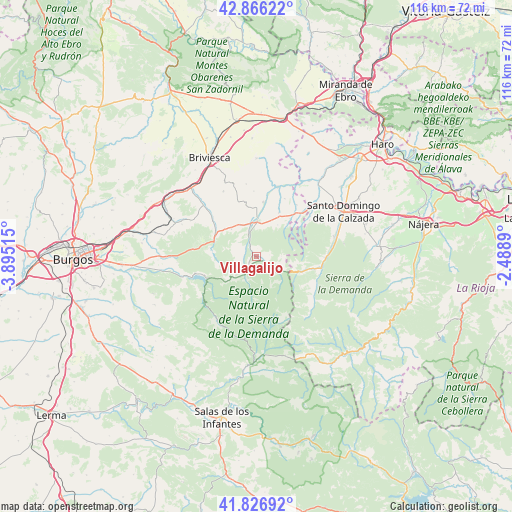
Villagalijo GPS coordinates[2]
42° 20' 55.392" North, 3° 11' 31.308" West
| Map corner | latitude | longitude |
|---|---|---|
| Upper-left | 42.86622°, | -3.89515° |
| Center: | 42.34872°, | -3.19203° |
| Lower-right: | 41.82692°, | -2.4889° |
| Map W x H: | 115.6×115.6 km | = 71.8×71.8mi |
| max Lat: | 43.74134° ⇑16.7% North |
| Villagalijo: | 42.34872° |
| min Lat: | ⇓83.3% South 27.64134° |
| min Long | Villagalijo | max Long |
| -18.00367° | -3.19203° | 4.2899° |
| W 51.7%⇐ | ⇒48.3% E |
Elevation
Elevation of Villagalijo is 899 m = 2949 ft, and this is 301 m = 988 ft above average elevation for this country.
| Max E: |
1682 m = 5518 ft | 19.8% |
| Villagalijo | 899 m 2949 ft | |
| Avg. | 598 m = 1962 ft | |
Min E: |
0 m = 0 ft | 80.2% |
See also: Spain elevation on elevation.city.
Geographical zone
Villagalijo is located in North temperate zone (between Tropic of Cancer and the Arctic Circle). Distance of this Northern Tropic circle is 2102.8 km =1306.6 mi to South.| Distance of | km | miles | from Villagalijo |
|---|---|---|---|
| North Pole | 5298.3 | 3292.2 | to North |
| Arctic Circle | 2692.4 | 1673 | to North |
| Tropic Cancer | 2102.8 | 1306.6 | to South |
| Equator | 4708.7 | 2925.8 | to South |


Nearby cities:
15 places around Villagalijo: (largest is in red/bold)
• Bascuñana
12.4 km =7.7 mi,  46°
46°
• Belorado
8 km =5 mi,  0°
0°
• Castildelgado
13.3 km =8.3 mi,  41°
41°
• Espinosa del Camino
9.6 km =6 mi,  311°
311°
• Fresneda de la Sierra Tirón
5.9 km =3.7 mi,  128°
128°
• Fresneña
8.6 km =5.3 mi,  33°
33°
• Pradoluengo
2.8 km =1.7 mi,  198°
198°
• Rábanos
7.2 km =4.5 mi,  243°
243°
• San Vicente del Valle
2.8 km =1.7 mi,  116°
116°
• Santa Cruz del Valle Urbión
5.4 km =3.4 mi,  206°
206°
• Tosantos
8.3 km =5.2 mi,  329°
329°
• Valgañón
10.8 km =6.7 mi,  108°
108°
• Valmala
7 km =4.3 mi,  227°
227°
• Viloria de Rioja
11.4 km =7.1 mi, 41°
• Zorraquín
12.8 km =8 mi,  101°
101°
Sources, notices
• [Note1] Compared only with cities in Spain existing in our database
• [Src1] Map data: © OpenStreetMap contributors (CC-BY-SA)
• [Src2] Other city data from geonames.org with taken over terms of usage.
• [Src3] Geographical zone / Annual Mean Temperature by Robert A. Rohde @ Wikipedia
