Arlanzón geodata
Arlanzón (Castille and León) is a seat of a third-order administrative division; located in Spain in Europe/Madrid (GMT+2) time zone. With population of 421 people, there are 4076 cities with bigger population in this country. Compared to other cities in Spain, 82.4% of cities are located further ↓South; 51.4% of cities are located further →East and 87.9% of cities have lower elevation than Arlanzón. Note1
Administrative division(s):
- Level 1: Castille and León
- Level 2: Provincia de Burgos
- Level 3: Arlanzón


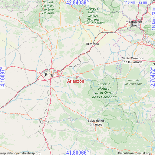
Arlanzón GPS coordinates[2]
42° 19' 21.612" North, 3° 27' 28.224" West
| Map corner | latitude | longitude |
|---|---|---|
| Upper-left | 42.84039°, | -4.16097° |
| Center: | 42.32267°, | -3.45784° |
| Lower-right: | 41.80066°, | -2.75472° |
| Map W x H: | 115.6×115.6 km | = 71.8×71.8mi |
| max Lat: | 43.74134° ⇑17.6% North |
| Arlanzón: | 42.32267° |
| min Lat: | ⇓82.4% South 27.64134° |
| min Long | Arlanzón | max Long |
| -18.00367° | -3.45784° | 4.2899° |
| W 48.6%⇐ | ⇒51.4% E |
Elevation
Elevation of Arlanzón is 996 m = 3268 ft, and this is 398 m = 1306 ft above average elevation for this country.
| Max E: |
1682 m = 5518 ft | 12.1% |
| Arlanzón | 996 m 3268 ft | |
| Avg. | 598 m = 1962 ft | |
Min E: |
0 m = 0 ft | 87.9% |
See also: Spain elevation on elevation.city.
Geographical zone
Arlanzón is located in North temperate zone (between Tropic of Cancer and the Arctic Circle). Distance of this Northern Tropic circle is 2099.9 km =1304.8 mi to South.| Distance of | km | miles | from Arlanzón |
|---|---|---|---|
| North Pole | 5301.2 | 3294 | to North |
| Arctic Circle | 2695.3 | 1674.8 | to North |
| Tropic Cancer | 2099.9 | 1304.8 | to South |
| Equator | 4705.8 | 2924 | to South |


Nearby cities:
15 places around Arlanzón: (largest is in red/bold)
• Arraya de Oca
11.4 km =7.1 mi,  25°
25°
• Atapuerca
7.4 km =4.6 mi,  326°
326°
• Barrios de Colina
8.1 km =5 mi,  358°
358°
• Carcedo de Burgos
14.1 km =8.8 mi,  253°
253°
• Cardeñajimeno
13.4 km =8.3 mi,  273°
273°
• Castrillo del Val
10.5 km =6.5 mi,  264°
264°
• Cerratón de Juarros
13.1 km =8.1 mi, 32°
• Fresno de Rodilla
11.1 km =6.9 mi,  348°
348°
• Ibeas de Juarros
6.4 km =4 mi,  278°
278°
• Palazuelos de la Sierra
12.3 km =7.6 mi,  180°
180°
• Quintanapalla
11.4 km =7.1 mi, 327°
• Rubena
12 km =7.5 mi,  306°
306°
• San Adrián de Juarros
5.6 km =3.5 mi,  195°
195°
• Santa María del Invierno
13.5 km =8.4 mi,  7°
7°
• Villaescusa la Sombría
10.8 km =6.7 mi,  17°
17°
Sources, notices
• [Note1] Compared only with cities in Spain existing in our database
• [Src1] Map data: © OpenStreetMap contributors (CC-BY-SA)
• [Src2] Other city data from geonames.org with taken over terms of usage.
• [Src3] Geographical zone / Annual Mean Temperature by Robert A. Rohde @ Wikipedia
