Sahagún geodata
Sahagún (Castille and León) is a seat of a third-order administrative division; located in Spain in Europe/Madrid (GMT+2) time zone. With population of 2,846 people, there are 1772 cities with bigger population in this country. Compared to other cities in Spain, 83.9% of cities are located further ↓South; 72.9% of cities are located further →East and 72.1% of cities have lower elevation than Sahagún. Note1


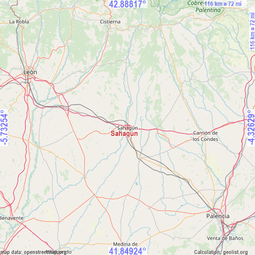
Sahagún GPS coordinates[2]
42° 22' 15.06" North, 5° 1' 45.912" West
| Map corner | latitude | longitude |
|---|---|---|
| Upper-left | 42.88817°, | -5.73254° |
| Center: | 42.37085°, | -5.02942° |
| Lower-right: | 41.84924°, | -4.32629° |
| Map W x H: | 115.5×115.5 km | = 71.8×71.8mi |
| max Lat: | 43.74134° ⇑16.1% North |
| Sahagún: | 42.37085° |
| min Lat: | ⇓83.9% South 27.64134° |
| min Long | Sahagún | max Long |
| -18.00367° | -5.02942° | 4.2899° |
| W 27.1%⇐ | ⇒72.9% E |
Elevation
Elevation of Sahagún is 828 m = 2717 ft, and this is 230 m = 755 ft above average elevation for this country.
| Max E: |
1682 m = 5518 ft | 27.9% |
| Sahagún | 828 m 2717 ft | |
| Avg. | 598 m = 1962 ft | |
Min E: |
0 m = 0 ft | 72.1% |
See also: Spain elevation on elevation.city.
Geographical zone
Sahagún is located in North temperate zone (between Tropic of Cancer and the Arctic Circle). Distance of this Northern Tropic circle is 2105.3 km =1308.2 mi to South.| Distance of | km | miles | from Sahagún |
|---|---|---|---|
| North Pole | 5295.9 | 3290.7 | to North |
| Arctic Circle | 2690 | 1671.5 | to North |
| Tropic Cancer | 2105.3 | 1308.2 | to South |
| Equator | 4711.2 | 2927.4 | to South |


Nearby cities:
15 places around Sahagún: (largest is in red/bold)
• Bercianos del Real Camino
9.6 km =6 mi,  280°
280°
• Calzada del Coto
4.3 km =2.7 mi,  293°
293°
• Cea
10.3 km =6.4 mi,  8°
8°
• Escobar de Campos
8.3 km =5.2 mi,  140°
140°
• Gordaliza del Pino
10.9 km =6.8 mi,  253°
253°
• Grajal de Campos
5.6 km =3.5 mi,  171°
171°
• Lagartos
11 km =6.8 mi,  69°
69°
• Ledigos
13.6 km =8.5 mi,  97°
97°
• Melgar de Arriba
12.7 km =7.9 mi,  205°
205°
• Moratinos
8.4 km =5.2 mi, 96°
• Población de Arroyo
13.3 km =8.3 mi,  106°
106°
• Santa María del Monte de Cea
15.2 km =9.4 mi,  331°
331°
• Vallecillo
15 km =9.3 mi,  263°
263°
• Villada
14.3 km =8.9 mi,  158°
158°
• Villamol
6.5 km =4 mi,  346°
346°
Sources, notices
• [Note1] Compared only with cities in Spain existing in our database
• [Src1] Map data: © OpenStreetMap contributors (CC-BY-SA)
• [Src2] Other city data from geonames.org with taken over terms of usage.
• [Src3] Geographical zone / Annual Mean Temperature by Robert A. Rohde @ Wikipedia
