Valdemanco geodata
Valdemanco (Madrid) is a seat of a third-order administrative division; located in Spain in Europe/Madrid (GMT+2) time zone. With population of 840 people, there are 3146 cities with bigger population in this country. Compared to other cities in Spain, 54.5% of cities are located further ↑North; 54.7% of cities are located further →East and 94.9% of cities have lower elevation than Valdemanco. Note1


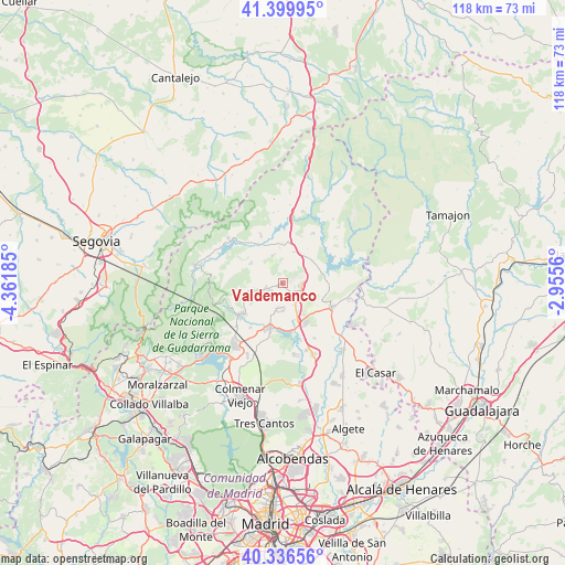
Valdemanco GPS coordinates[2]
40° 52' 13.404" North, 3° 39' 31.428" West
| Map corner | latitude | longitude |
|---|---|---|
| Upper-left | 41.39995°, | -4.36185° |
| Center: | 40.87039°, | -3.65873° |
| Lower-right: | 40.33656°, | -2.9556° |
| Map W x H: | 118.2×118.2 km | = 73.4×73.4mi |
| max Lat: | 43.74134° ⇑54.5% North |
| Valdemanco: | 40.87039° |
| min Lat: | ⇓45.5% South 27.64134° |
| min Long | Valdemanco | max Long |
| -18.00367° | -3.65873° | 4.2899° |
| W 45.3%⇐ | ⇒54.7% E |
Elevation
Elevation of Valdemanco is 1134 m = 3720 ft, and this is 536 m = 1759 ft above average elevation for this country.
| Max E: |
1682 m = 5518 ft | 5.1% |
| Valdemanco | 1134 m 3720 ft | |
| Avg. | 598 m = 1962 ft | |
Min E: |
0 m = 0 ft | 94.9% |
See also: Spain elevation on elevation.city.
Geographical zone
Valdemanco is located in North temperate zone (between Tropic of Cancer and the Arctic Circle). Distance of this Northern Tropic circle is 1938.4 km =1204.5 mi to South.| Distance of | km | miles | from Valdemanco |
|---|---|---|---|
| North Pole | 5462.7 | 3394.4 | to North |
| Arctic Circle | 2856.8 | 1775.1 | to North |
| Tropic Cancer | 1938.4 | 1204.5 | to South |
| Equator | 4544.4 | 2823.8 | to South |


Nearby cities:
15 places around Valdemanco: (largest is in red/bold)
• Buitrago del Lozoya
13.6 km =8.5 mi,  8°
8°
• Bustarviejo
4.4 km =2.7 mi,  250°
250°
• Cabanillas de la Sierra
6.3 km =3.9 mi,  152°
152°
• Canencia
7.6 km =4.7 mi,  302°
302°
• Cervera de Buitrago
12.4 km =7.7 mi,  63°
63°
• El Vellón
13.5 km =8.4 mi, 150°
• Garganta de los Montes
5.9 km =3.7 mi,  339°
339°
• Guadalix de la Sierra
9.9 km =6.2 mi,  197°
197°
• La Cabrera
3.9 km =2.4 mi,  100°
100°
• Miraflores de la Sierra
10.6 km =6.6 mi,  234°
234°
• Navalafuente
5.7 km =3.5 mi,  191°
191°
• Redueña
7.8 km =4.8 mi,  139°
139°
• Torrelaguna
11.3 km =7 mi,  114°
114°
• Torremocha de Jarama
14 km =8.7 mi, 103°
• Venturada
8.8 km =5.5 mi,  158°
158°
Sources, notices
• [Note1] Compared only with cities in Spain existing in our database
• [Src1] Map data: © OpenStreetMap contributors (CC-BY-SA)
• [Src2] Other city data from geonames.org with taken over terms of usage.
• [Src3] Geographical zone / Annual Mean Temperature by Robert A. Rohde @ Wikipedia
