La Cabrera geodata
La Cabrera (Madrid) is a populated place; located in Spain in Europe/Madrid (GMT+2) time zone. With population of 2,265 people, there are 2018 cities with bigger population in this country. Compared to other cities in Spain, 54.7% of cities are located further ↑North; 53.9% of cities are located further →East and 90.1% of cities have lower elevation than La Cabrera. Note1


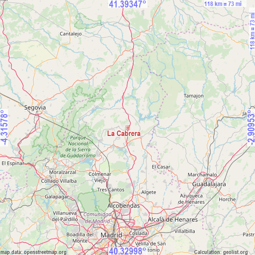
La Cabrera GPS coordinates[2]
40° 51' 49.896" North, 3° 36' 45.54" West
| Map corner | latitude | longitude |
|---|---|---|
| Upper-left | 41.39347°, | -4.31578° |
| Center: | 40.86386°, | -3.61265° |
| Lower-right: | 40.32998°, | -2.90953° |
| Map W x H: | 118.2×118.2 km | = 73.4×73.4mi |
| max Lat: | 43.74134° ⇑54.7% North |
| La Cabrera: | 40.86386° |
| min Lat: | ⇓45.3% South 27.64134° |
| min Long | La Cabrera | max Long |
| -18.00367° | -3.61265° | 4.2899° |
| W 46.1%⇐ | ⇒53.9% E |
Elevation
Elevation of La Cabrera is 1033 m = 3389 ft, and this is 435 m = 1427 ft above average elevation for this country.
| Max E: |
1682 m = 5518 ft | 9.9% |
| La Cabrera | 1033 m 3389 ft | |
| Avg. | 598 m = 1962 ft | |
Min E: |
0 m = 0 ft | 90.1% |
See also: Spain elevation on elevation.city.
Geographical zone
La Cabrera is located in North temperate zone (between Tropic of Cancer and the Arctic Circle). Distance of this Northern Tropic circle is 1937.7 km =1204 mi to South.| Distance of | km | miles | from La Cabrera |
|---|---|---|---|
| North Pole | 5463.4 | 3394.8 | to North |
| Arctic Circle | 2857.5 | 1775.6 | to North |
| Tropic Cancer | 1937.7 | 1204 | to South |
| Equator | 4543.6 | 2823.3 | to South |


Nearby cities:
15 places around La Cabrera: (largest is in red/bold)
• Bustarviejo
8 km =5 mi,  264°
264°
• Cabanillas de la Sierra
5 km =3.1 mi,  191°
191°
• Canencia
11.4 km =7.1 mi,  295°
295°
• Cervera de Buitrago
9.5 km =5.9 mi,  49°
49°
• El Vellón
11.3 km =7 mi,  165°
165°
• Garganta de los Montes
8.6 km =5.3 mi,  316°
316°
• Guadalix de la Sierra
11.1 km =6.9 mi,  217°
217°
• Navalafuente
7 km =4.3 mi,  226°
226°
• Patones
10.8 km =6.7 mi,  94°
94°
• Redueña
5.4 km =3.4 mi, 167°
• Robledillo de la Jara
12.3 km =7.6 mi,  38°
38°
• Torrelaguna
7.5 km =4.7 mi,  122°
122°
• Torremocha de Jarama
10.1 km =6.3 mi,  104°
104°
• Valdemanco
3.9 km =2.4 mi,  280°
280°
• Venturada
7.4 km =4.6 mi,  184°
184°
Sources, notices
• [Note1] Compared only with cities in Spain existing in our database
• [Src1] Map data: © OpenStreetMap contributors (CC-BY-SA)
• [Src2] Other city data from geonames.org with taken over terms of usage.
• [Src3] Geographical zone / Annual Mean Temperature by Robert A. Rohde @ Wikipedia
