Canencia geodata
Canencia (Madrid) is a seat of a third-order administrative division; located in Spain in Europe/Madrid (GMT+2) time zone. With population of 442 people, there are 4024 cities with bigger population in this country. Compared to other cities in Spain, 53.6% of cities are located further ↑North; 55.9% of cities are located further →East and 96.1% of cities have lower elevation than Canencia. Note1


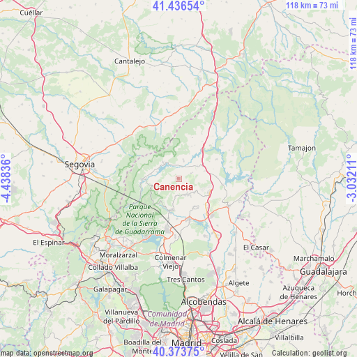
Canencia GPS coordinates[2]
40° 54' 26.208" North, 3° 44' 6.828" West
| Map corner | latitude | longitude |
|---|---|---|
| Upper-left | 41.43654°, | -4.43836° |
| Center: | 40.90728°, | -3.73523° |
| Lower-right: | 40.37375°, | -3.03211° |
| Map W x H: | 118.2×118.2 km | = 73.4×73.4mi |
| max Lat: | 43.74134° ⇑53.6% North |
| Canencia: | 40.90728° |
| min Lat: | ⇓46.4% South 27.64134° |
| min Long | Canencia | max Long |
| -18.00367° | -3.73523° | 4.2899° |
| W 44.1%⇐ | ⇒55.9% E |
Elevation
Elevation of Canencia is 1172 m = 3845 ft, and this is 574 m = 1883 ft above average elevation for this country.
| Max E: |
1682 m = 5518 ft | 3.9% |
| Canencia | 1172 m 3845 ft | |
| Avg. | 598 m = 1962 ft | |
Min E: |
0 m = 0 ft | 96.1% |
See also: Spain elevation on elevation.city.
Geographical zone
Canencia is located in North temperate zone (between Tropic of Cancer and the Arctic Circle). Distance of this Northern Tropic circle is 1942.5 km =1207 mi to South.| Distance of | km | miles | from Canencia |
|---|---|---|---|
| North Pole | 5458.6 | 3391.8 | to North |
| Arctic Circle | 2852.7 | 1772.6 | to North |
| Tropic Cancer | 1942.5 | 1207 | to South |
| Equator | 4548.5 | 2826.3 | to South |


Nearby cities:
15 places around Canencia: (largest is in red/bold)
• Alameda del Valle
9.1 km =5.7 mi,  278°
278°
• Buitrago del Lozoya
12.6 km =7.8 mi,  42°
42°
• Bustarviejo
6 km =3.7 mi,  157°
157°
• Cabanillas de la Sierra
13.4 km =8.3 mi,  136°
136°
• Garganta de los Montes
4.5 km =2.8 mi,  72°
72°
• Gascones
14.6 km =9.1 mi,  32°
32°
• Guadalix de la Sierra
14 km =8.7 mi,  165°
165°
• La Cabrera
11.4 km =7.1 mi,  115°
115°
• Lozoya
6.6 km =4.1 mi,  315°
315°
• Miraflores de la Sierra
10.5 km =6.5 mi,  192°
192°
• Navalafuente
11 km =6.8 mi,  151°
151°
• Pinilla del Valle
7.1 km =4.4 mi,  285°
285°
• Rascafría
12.1 km =7.5 mi,  268°
268°
• Valdemanco
7.6 km =4.7 mi, 122°
• Villavieja del Lozoya
12.1 km =7.5 mi, 27°
Sources, notices
• [Note1] Compared only with cities in Spain existing in our database
• [Src1] Map data: © OpenStreetMap contributors (CC-BY-SA)
• [Src2] Other city data from geonames.org with taken over terms of usage.
• [Src3] Geographical zone / Annual Mean Temperature by Robert A. Rohde @ Wikipedia
