Navalafuente geodata
Navalafuente (Madrid) is a seat of a third-order administrative division; located in Spain in Europe/Madrid (GMT+2) time zone. With population of 765 people, there are 3281 cities with bigger population in this country. Compared to other cities in Spain, 55.7% of cities are located further ↑North; 54.9% of cities are located further →East and 80.1% of cities have lower elevation than Navalafuente. Note1


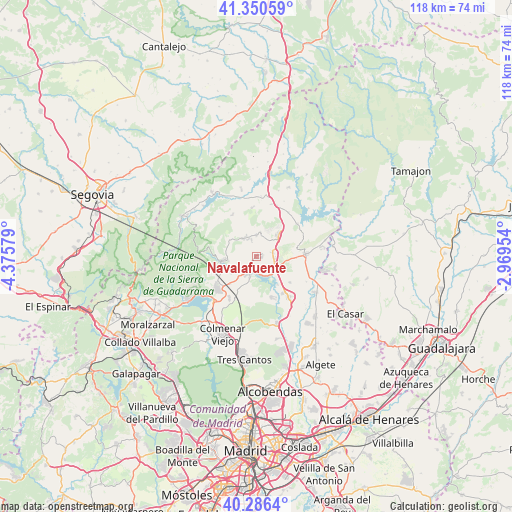
Navalafuente GPS coordinates[2]
40° 49' 14.268" North, 3° 40' 21.576" West
| Map corner | latitude | longitude |
|---|---|---|
| Upper-left | 41.35059°, | -4.37579° |
| Center: | 40.82063°, | -3.67266° |
| Lower-right: | 40.2864°, | -2.96954° |
| Map W x H: | 118.3×118.3 km | = 73.5×73.5mi |
| max Lat: | 43.74134° ⇑55.7% North |
| Navalafuente: | 40.82063° |
| min Lat: | ⇓44.3% South 27.64134° |
| min Long | Navalafuente | max Long |
| -18.00367° | -3.67266° | 4.2899° |
| W 45.1%⇐ | ⇒54.9% E |
Elevation
Elevation of Navalafuente is 898 m = 2946 ft, and this is 300 m = 984 ft above average elevation for this country.
| Max E: |
1682 m = 5518 ft | 19.9% |
| Navalafuente | 898 m 2946 ft | |
| Avg. | 598 m = 1962 ft | |
Min E: |
0 m = 0 ft | 80.1% |
See also: Spain elevation on elevation.city.
Geographical zone
Navalafuente is located in North temperate zone (between Tropic of Cancer and the Arctic Circle). Distance of this Northern Tropic circle is 1932.9 km =1201 mi to South.| Distance of | km | miles | from Navalafuente |
|---|---|---|---|
| North Pole | 5468.2 | 3397.8 | to North |
| Arctic Circle | 2862.3 | 1778.6 | to North |
| Tropic Cancer | 1932.9 | 1201 | to South |
| Equator | 4538.8 | 2820.3 | to South |


Nearby cities:
15 places around Navalafuente: (largest is in red/bold)
• Bustarviejo
5 km =3.1 mi,  324°
324°
• Cabanillas de la Sierra
4.1 km =2.5 mi,  90°
90°
• Canencia
11 km =6.8 mi,  331°
331°
• El Molar
12.6 km =7.8 mi,  141°
141°
• El Vellón
10 km =6.2 mi,  128°
128°
• Garganta de los Montes
11.1 km =6.9 mi,  355°
355°
• Guadalix de la Sierra
4.3 km =2.7 mi,  203°
203°
• La Cabrera
7 km =4.3 mi,  46°
46°
• Miraflores de la Sierra
7.6 km =4.7 mi,  265°
265°
• Pedrezuela
10.6 km =6.6 mi, 144°
• Redueña
6.3 km =3.9 mi, 93°
• Torrelaguna
11.5 km =7.1 mi, 86°
• Torremocha de Jarama
15 km =9.3 mi,  81°
81°
• Valdemanco
5.7 km =3.5 mi,  11°
11°
• Venturada
5.2 km =3.2 mi,  120°
120°
Sources, notices
• [Note1] Compared only with cities in Spain existing in our database
• [Src1] Map data: © OpenStreetMap contributors (CC-BY-SA)
• [Src2] Other city data from geonames.org with taken over terms of usage.
• [Src3] Geographical zone / Annual Mean Temperature by Robert A. Rohde @ Wikipedia
