Valdehijaderos geodata
Valdehijaderos (Castille and León) is a seat of a third-order administrative division; located in Spain in Europe/Madrid (GMT+2) time zone. With population of 108 people, there are 5829 cities with bigger population in this country. Compared to other cities in Spain, 63.6% of cities are located further ↑North; 83.9% of cities are located further →East and 65.2% of cities have lower elevation than Valdehijaderos. Note1
Administrative division(s):
- Level 1: Castille and León
- Level 2: Provincia de Salamanca
- Level 3: Valdehijaderos


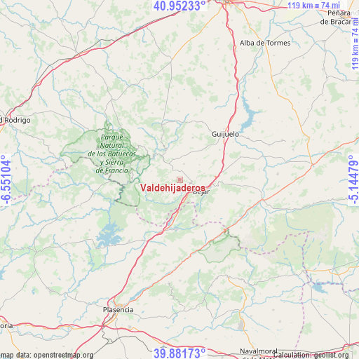
Valdehijaderos GPS coordinates[2]
40° 25' 8.976" North, 5° 50' 52.512" West
| Map corner | latitude | longitude |
|---|---|---|
| Upper-left | 40.95233°, | -6.55104° |
| Center: | 40.41916°, | -5.84792° |
| Lower-right: | 39.88173°, | -5.14479° |
| Map W x H: | 119×119 km | = 73.9×73.9mi |
| max Lat: | 43.74134° ⇑63.6% North |
| Valdehijaderos: | 40.41916° |
| min Lat: | ⇓36.4% South 27.64134° |
| min Long | Valdehijaderos | max Long |
| -18.00367° | -5.84792° | 4.2899° |
| W 16.1%⇐ | ⇒83.9% E |
Elevation
Elevation of Valdehijaderos is 779 m = 2556 ft, and this is 181 m = 594 ft above average elevation for this country.
| Max E: |
1682 m = 5518 ft | 34.8% |
| Valdehijaderos | 779 m 2556 ft | |
| Avg. | 598 m = 1962 ft | |
Min E: |
0 m = 0 ft | 65.2% |
See also: Spain elevation on elevation.city.
Geographical zone
Valdehijaderos is located in North temperate zone (between Tropic of Cancer and the Arctic Circle). Distance of this Northern Tropic circle is 1888.3 km =1173.3 mi to South.| Distance of | km | miles | from Valdehijaderos |
|---|---|---|---|
| North Pole | 5512.9 | 3425.6 | to North |
| Arctic Circle | 2907 | 1806.3 | to North |
| Tropic Cancer | 1888.3 | 1173.3 | to South |
| Equator | 4494.2 | 2792.6 | to South |


Nearby cities:
15 places around Valdehijaderos: (largest is in red/bold)
• Aldeacipreste
6 km =3.7 mi,  224°
224°
• Béjar
8 km =5 mi,  116°
116°
• Cantagallo
5.8 km =3.6 mi,  154°
154°
• Colmenar de Montemayor
9.4 km =5.8 mi,  256°
256°
• Cristóbal
6.6 km =4.1 mi,  327°
327°
• Horcajo de Montemayor
3.9 km =2.4 mi,  275°
275°
• Montemayor del Río
8.8 km =5.5 mi,  206°
206°
• Navalmoral de Béjar
5.5 km =3.4 mi,  85°
85°
• Peromingo
8.1 km =5 mi,  52°
52°
• Peñacaballera
8.5 km =5.3 mi,  187°
187°
• Pinedas
9.9 km =6.2 mi,  286°
286°
• Puerto de Béjar
7.7 km =4.8 mi,  173°
173°
• Sanchotello
8.2 km =5.1 mi,  75°
75°
• Valdefuentes de Sangusín
5.3 km =3.3 mi,  13°
13°
• Valverde de Valdelacasa
8.9 km =5.5 mi,  39°
39°
Sources, notices
• [Note1] Compared only with cities in Spain existing in our database
• [Src1] Map data: © OpenStreetMap contributors (CC-BY-SA)
• [Src2] Other city data from geonames.org with taken over terms of usage.
• [Src3] Geographical zone / Annual Mean Temperature by Robert A. Rohde @ Wikipedia
