Navalmoral de Béjar geodata
Navalmoral de Béjar (Castille and León) is a seat of a third-order administrative division; located in Spain in Europe/Madrid (GMT+2) time zone. With population of 63 people, there are 6314 cities with bigger population in this country. Compared to other cities in Spain, 63.6% of cities are located further ↑North; 83% of cities are located further →East and 82.7% of cities have lower elevation than Navalmoral de Béjar. Note1
Administrative division(s):
- Level 1: Castille and León
- Level 2: Provincia de Salamanca
- Level 3: Navalmoral de Béjar


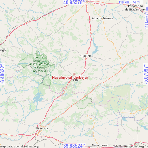
Navalmoral de Béjar GPS coordinates[2]
40° 25' 21.504" North, 5° 46' 59.16" West
| Map corner | latitude | longitude |
|---|---|---|
| Upper-left | 40.95578°, | -6.48622° |
| Center: | 40.42264°, | -5.7831° |
| Lower-right: | 39.88524°, | -5.07997° |
| Map W x H: | 119×119 km | = 73.9×73.9mi |
| max Lat: | 43.74134° ⇑63.6% North |
| Navalmoral de Béjar: | 40.42264° |
| min Lat: | ⇓36.4% South 27.64134° |
| min Long | Navalmoral de B | max Long |
| -18.00367° | -5.7831° | 4.2899° |
| W 17%⇐ | ⇒83% E |
Elevation
Elevation of Navalmoral de Béjar is 924 m = 3031 ft, and this is 326 m = 1070 ft above average elevation for this country.
| Max E: |
1682 m = 5518 ft | 17.3% |
| Navalmoral de Béjar | 924 m 3031 ft | |
| Avg. | 598 m = 1962 ft | |
Min E: |
0 m = 0 ft | 82.7% |
See also: Spain elevation on elevation.city.
Geographical zone
Navalmoral de Béjar is located in North temperate zone (between Tropic of Cancer and the Arctic Circle). Distance of this Northern Tropic circle is 1888.7 km =1173.6 mi to South.| Distance of | km | miles | from Navalmoral de Béjar |
|---|---|---|---|
| North Pole | 5512.5 | 3425.3 | to North |
| Arctic Circle | 2906.6 | 1806.1 | to North |
| Tropic Cancer | 1888.7 | 1173.6 | to South |
| Equator | 4494.6 | 2792.8 | to South |


Nearby cities:
15 places around Navalmoral de Béjar: (largest is in red/bold)
• Béjar
4.4 km =2.7 mi,  157°
157°
• Candelario
6.9 km =4.3 mi,  151°
151°
• Cantagallo
6.4 km =4 mi,  208°
208°
• Fresnedoso
6.4 km =4 mi,  76°
76°
• Ledrada
7.4 km =4.6 mi,  45°
45°
• Navacarros
6.5 km =4 mi,  115°
115°
• Peromingo
4.7 km =2.9 mi,  11°
11°
• Puerto de Béjar
9.3 km =5.8 mi, 209°
• Sanchotello
3 km =1.9 mi,  55°
55°
• Sorihuela
9.2 km =5.7 mi, 75°
• Valdefuentes de Sangusín
6.4 km =4 mi,  318°
318°
• Valdehijaderos
5.5 km =3.4 mi,  265°
265°
• Valdelacasa
9.4 km =5.8 mi, 10°
• Vallejera de Riofrío
5.6 km =3.5 mi,  105°
105°
• Valverde de Valdelacasa
6.6 km =4.1 mi,  1°
1°
Sources, notices
• [Note1] Compared only with cities in Spain existing in our database
• [Src1] Map data: © OpenStreetMap contributors (CC-BY-SA)
• [Src2] Other city data from geonames.org with taken over terms of usage.
• [Src3] Geographical zone / Annual Mean Temperature by Robert A. Rohde @ Wikipedia
