Valdearenas geodata
Valdearenas (Castille-La Mancha) is a seat of a third-order administrative division; located in Spain in Europe/Madrid (GMT+2) time zone. With population of 89 people, there are 6055 cities with bigger population in this country. Compared to other cities in Spain, 56% of cities are located further ↑North; 54.7% of cities are located further ←West and 66.8% of cities have lower elevation than Valdearenas. Note1
Administrative division(s):
- Level 1: Castille-La Mancha
- Level 2: Provincia de Guadalajara
- Level 3: Valdearenas


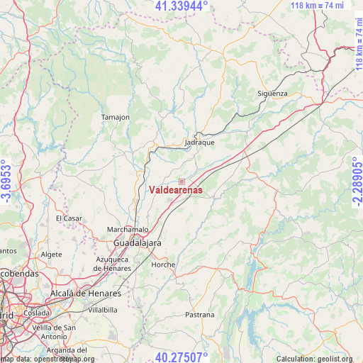
Valdearenas GPS coordinates[2]
40° 48' 33.804" North, 2° 59' 31.848" West
| Map corner | latitude | longitude |
|---|---|---|
| Upper-left | 41.33944°, | -3.6953° |
| Center: | 40.80939°, | -2.99218° |
| Lower-right: | 40.27507°, | -2.28905° |
| Map W x H: | 118.3×118.3 km | = 73.5×73.5mi |
| max Lat: | 43.74134° ⇑56% North |
| Valdearenas: | 40.80939° |
| min Lat: | ⇓44% South 27.64134° |
| min Long | Valdearenas | max Long |
| -18.00367° | -2.99218° | 4.2899° |
| W 54.7%⇐ | ⇒45.3% E |
Elevation
Elevation of Valdearenas is 790 m = 2592 ft, and this is 192 m = 630 ft above average elevation for this country.
| Max E: |
1682 m = 5518 ft | 33.2% |
| Valdearenas | 790 m 2592 ft | |
| Avg. | 598 m = 1962 ft | |
Min E: |
0 m = 0 ft | 66.8% |
See also: Spain elevation on elevation.city.
Geographical zone
Valdearenas is located in North temperate zone (between Tropic of Cancer and the Arctic Circle). Distance of this Northern Tropic circle is 1931.7 km =1200.3 mi to South.| Distance of | km | miles | from Valdearenas |
|---|---|---|---|
| North Pole | 5469.5 | 3398.6 | to North |
| Arctic Circle | 2863.6 | 1779.4 | to North |
| Tropic Cancer | 1931.7 | 1200.3 | to South |
| Equator | 4537.6 | 2819.5 | to South |


Nearby cities:
15 places around Valdearenas: (largest is in red/bold)
• Alarilla
10.2 km =6.3 mi,  294°
294°
• Casas de San Galindo
7.6 km =4.7 mi,  22°
22°
• Cañizar
7.6 km =4.7 mi,  232°
232°
• Ciruelas
10.3 km =6.4 mi, 230°
• Copernal
8 km =5 mi,  319°
319°
• Gajanejos
9.1 km =5.7 mi,  67°
67°
• Hita
4.7 km =2.9 mi, 286°
• Miralrío
9.8 km =6.1 mi, 24°
• Muduex
3.6 km =2.2 mi,  51°
51°
• Taragudo
7.2 km =4.5 mi,  280°
280°
• Torija
8 km =5 mi,  202°
202°
• Torre del Burgo
7.4 km =4.6 mi,  254°
254°
• Trijueque
3.9 km =2.4 mi,  180°
180°
• Utande
6.9 km =4.3 mi, 51°
• Valdegrudas
11 km =6.8 mi,  188°
188°
Sources, notices
• [Note1] Compared only with cities in Spain existing in our database
• [Src1] Map data: © OpenStreetMap contributors (CC-BY-SA)
• [Src2] Other city data from geonames.org with taken over terms of usage.
• [Src3] Geographical zone / Annual Mean Temperature by Robert A. Rohde @ Wikipedia
