Valdegrudas geodata
Valdegrudas (Castille-La Mancha) is a seat of a third-order administrative division; located in Spain in Europe/Madrid (GMT+2) time zone. With population of 63 people, there are 6314 cities with bigger population in this country. Compared to other cities in Spain, 57.8% of cities are located further ↑North; 54.2% of cities are located further ←West and 86.8% of cities have lower elevation than Valdegrudas. Note1
Administrative division(s):
- Level 1: Castille-La Mancha
- Level 2: Provincia de Guadalajara
- Level 3: Valdegrudas


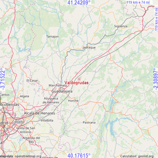
Valdegrudas GPS coordinates[2]
40° 42' 40.5" North, 3° 0' 43.524" West
| Map corner | latitude | longitude |
|---|---|---|
| Upper-left | 41.24209°, | -3.71522° |
| Center: | 40.71125°, | -3.01209° |
| Lower-right: | 40.17615°, | -2.30897° |
| Map W x H: | 118.5×118.5 km | = 73.6×73.6mi |
| max Lat: | 43.74134° ⇑57.8% North |
| Valdegrudas: | 40.71125° |
| min Lat: | ⇓42.2% South 27.64134° |
| min Long | Valdegrudas | max Long |
| -18.00367° | -3.01209° | 4.2899° |
| W 54.2%⇐ | ⇒45.8% E |
Elevation
Elevation of Valdegrudas is 977 m = 3205 ft, and this is 379 m = 1243 ft above average elevation for this country.
| Max E: |
1682 m = 5518 ft | 13.2% |
| Valdegrudas | 977 m 3205 ft | |
| Avg. | 598 m = 1962 ft | |
Min E: |
0 m = 0 ft | 86.8% |
See also: Spain elevation on elevation.city.
Geographical zone
Valdegrudas is located in North temperate zone (between Tropic of Cancer and the Arctic Circle). Distance of this Northern Tropic circle is 1920.7 km =1193.5 mi to South.| Distance of | km | miles | from Valdegrudas |
|---|---|---|---|
| North Pole | 5480.4 | 3405.4 | to North |
| Arctic Circle | 2874.5 | 1786.1 | to North |
| Tropic Cancer | 1920.7 | 1193.5 | to South |
| Equator | 4526.7 | 2812.8 | to South |


Nearby cities:
15 places around Valdegrudas: (largest is in red/bold)
• Aldeanueva de Guadalajara
4.4 km =2.7 mi,  217°
217°
• Atanzón
5.1 km =3.2 mi,  165°
165°
• Caspueñas
3.3 km =2.1 mi,  123°
123°
• Cañizar
7.6 km =4.7 mi,  325°
325°
• Centenera
7.5 km =4.7 mi,  206°
206°
• Ciruelas
7.6 km =4.7 mi,  304°
304°
• Hita
12.6 km =7.8 mi,  347°
347°
• Lupiana
11.9 km =7.4 mi,  196°
196°
• Torija
3.7 km =2.3 mi,  338°
338°
• Torre del Burgo
10.5 km =6.5 mi, 328°
• Trijueque
7.2 km =4.5 mi,  13°
13°
• Tórtola de Henares
9.4 km =5.8 mi,  265°
265°
• Valdearenas
11 km =6.8 mi, 8°
• Valdeavellano
6.2 km =3.9 mi,  144°
144°
• Valfermoso de Tajuña
11.4 km =7.1 mi,  154°
154°
Sources, notices
• [Note1] Compared only with cities in Spain existing in our database
• [Src1] Map data: © OpenStreetMap contributors (CC-BY-SA)
• [Src2] Other city data from geonames.org with taken over terms of usage.
• [Src3] Geographical zone / Annual Mean Temperature by Robert A. Rohde @ Wikipedia
