Hita geodata
Hita (Castille-La Mancha) is a seat of a third-order administrative division; located in Spain in Europe/Madrid (GMT+2) time zone. With population of 300 people, there are 4499 cities with bigger population in this country. Compared to other cities in Spain, 55.6% of cities are located further ↑North; 53.7% of cities are located further ←West and 70.2% of cities have lower elevation than Hita. Note1
Administrative division(s):
- Level 1: Castille-La Mancha
- Level 2: Provincia de Guadalajara
- Level 3: Hita


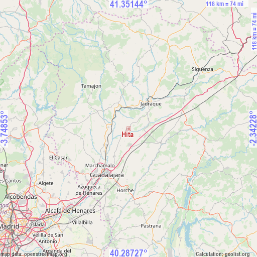
Hita GPS coordinates[2]
40° 49' 17.364" North, 3° 2' 43.44" West
| Map corner | latitude | longitude |
|---|---|---|
| Upper-left | 41.35144°, | -3.74853° |
| Center: | 40.82149°, | -3.0454° |
| Lower-right: | 40.28727°, | -2.34228° |
| Map W x H: | 118.3×118.3 km | = 73.5×73.5mi |
| max Lat: | 43.74134° ⇑55.6% North |
| Hita: | 40.82149° |
| min Lat: | ⇓44.4% South 27.64134° |
| min Long | Hita | max Long |
| -18.00367° | -3.0454° | 4.2899° |
| W 53.7%⇐ | ⇒46.3% E |
Elevation
Elevation of Hita is 815 m = 2674 ft, and this is 217 m = 712 ft above average elevation for this country.
| Max E: |
1682 m = 5518 ft | 29.8% |
| Hita | 815 m 2674 ft | |
| Avg. | 598 m = 1962 ft | |
Min E: |
0 m = 0 ft | 70.2% |
See also: Spain elevation on elevation.city.
Geographical zone
Hita is located in North temperate zone (between Tropic of Cancer and the Arctic Circle). Distance of this Northern Tropic circle is 1933 km =1201.1 mi to South.| Distance of | km | miles | from Hita |
|---|---|---|---|
| North Pole | 5468.1 | 3397.7 | to North |
| Arctic Circle | 2862.2 | 1778.5 | to North |
| Tropic Cancer | 1933 | 1201.1 | to South |
| Equator | 4538.9 | 2820.3 | to South |


Nearby cities:
15 places around Hita: (largest is in red/bold)
• Alarilla
5.6 km =3.5 mi,  300°
300°
• Casas de San Galindo
9.3 km =5.8 mi,  52°
52°
• Cañizar
6.2 km =3.9 mi,  194°
194°
• Ciruelas
8.6 km =5.3 mi,  203°
203°
• Copernal
4.9 km =3 mi,  351°
351°
• Espinosa de Henares
9 km =5.6 mi, 346°
• Humanes
9 km =5.6 mi,  273°
273°
• Mohernando
10.9 km =6.8 mi,  258°
258°
• Muduex
7.3 km =4.5 mi,  83°
83°
• Taragudo
2.6 km =1.6 mi, 268°
• Torija
8.9 km =5.5 mi,  170°
170°
• Torre del Burgo
4.3 km =2.7 mi,  219°
219°
• Trijueque
6.9 km =4.3 mi,  139°
139°
• Utande
10.3 km =6.4 mi,  73°
73°
• Valdearenas
4.7 km =2.9 mi,  106°
106°
Sources, notices
• [Note1] Compared only with cities in Spain existing in our database
• [Src1] Map data: © OpenStreetMap contributors (CC-BY-SA)
• [Src2] Other city data from geonames.org with taken over terms of usage.
• [Src3] Geographical zone / Annual Mean Temperature by Robert A. Rohde @ Wikipedia
