Uncastillo geodata
Uncastillo (Aragon) is a seat of a third-order administrative division; located in Spain in Europe/Madrid (GMT+2) time zone. With population of 852 people, there are 3130 cities with bigger population in this country. Compared to other cities in Spain, 83.6% of cities are located further ↓South; 76.1% of cities are located further ←West and 53.7% of cities have higher elevation than Uncastillo. Note1


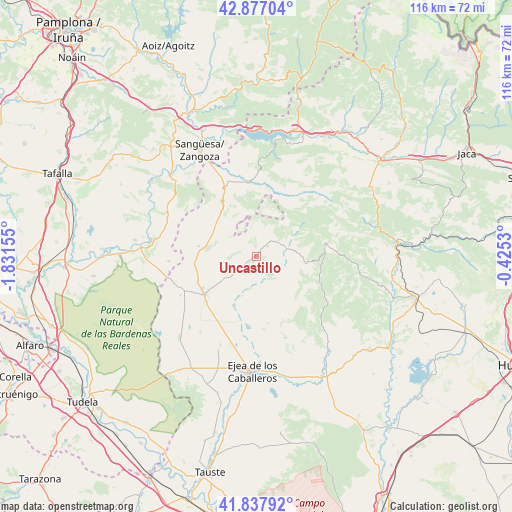
Uncastillo GPS coordinates[2]
42° 21' 34.668" North, 1° 7' 42.312" West
| Map corner | latitude | longitude |
|---|---|---|
| Upper-left | 42.87704°, | -1.83155° |
| Center: | 42.35963°, | -1.12842° |
| Lower-right: | 41.83792°, | -0.4253° |
| Map W x H: | 115.5×115.5 km | = 71.8×71.8mi |
| max Lat: | 43.74134° ⇑16.4% North |
| Uncastillo: | 42.35963° |
| min Lat: | ⇓83.6% South 27.64134° |
| min Long | Uncastillo | max Long |
| -18.00367° | -1.12842° | 4.2899° |
| W 76.1%⇐ | ⇒23.9% E |
Elevation
Elevation of Uncastillo is 614 m = 2014 ft, and this is 16 m = 52 ft above average elevation for this country.
| Max E: |
1682 m = 5518 ft | 53.7% |
| Uncastillo | 614 m 2014 ft | |
| Avg. | 598 m = 1962 ft | |
Min E: |
0 m = 0 ft | 46.3% |
See also: Spain elevation on elevation.city.
Geographical zone
Uncastillo is located in North temperate zone (between Tropic of Cancer and the Arctic Circle). Distance of this Northern Tropic circle is 2104 km =1307.4 mi to South.| Distance of | km | miles | from Uncastillo |
|---|---|---|---|
| North Pole | 5297.1 | 3291.5 | to North |
| Arctic Circle | 2691.2 | 1672.2 | to North |
| Tropic Cancer | 2104 | 1307.4 | to South |
| Equator | 4709.9 | 2926.6 | to South |


Nearby cities:
15 places around Uncastillo: (largest is in red/bold)
• Asin
10.8 km =6.7 mi,  141°
141°
• Biel
15.7 km =9.8 mi,  78°
78°
• Biota
11.9 km =7.4 mi,  204°
204°
• Castiliscar
12 km =7.5 mi,  279°
279°
• Isuerre
15.5 km =9.6 mi,  23°
23°
• Layana
11.9 km =7.4 mi,  233°
233°
• Lobera de Onsella
15.8 km =9.8 mi,  33°
33°
• Longás
20.9 km =13 mi,  49°
49°
• Luesia
8.6 km =5.3 mi, 82°
• Navardún
17.1 km =10.6 mi,  354°
354°
• Orés
13.9 km =8.6 mi,  131°
131°
• Petilla de Aragón
10.1 km =6.3 mi,  5°
5°
• Sos del Rey Católico
16.8 km =10.4 mi,  334°
334°
• Sádaba
14.5 km =9 mi, 233°
• Urriés
17.8 km =11.1 mi,  359°
359°
Sources, notices
• [Note1] Compared only with cities in Spain existing in our database
• [Src1] Map data: © OpenStreetMap contributors (CC-BY-SA)
• [Src2] Other city data from geonames.org with taken over terms of usage.
• [Src3] Geographical zone / Annual Mean Temperature by Robert A. Rohde @ Wikipedia
