Castiliscar geodata
Castiliscar (Aragon) is a seat of a third-order administrative division; located in Spain in Europe/Madrid (GMT+2) time zone. With population of 401 people, there are 4135 cities with bigger population in this country. Compared to other cities in Spain, 84% of cities are located further ↓South; 75% of cities are located further ←West and 62.6% of cities have higher elevation than Castiliscar. Note1


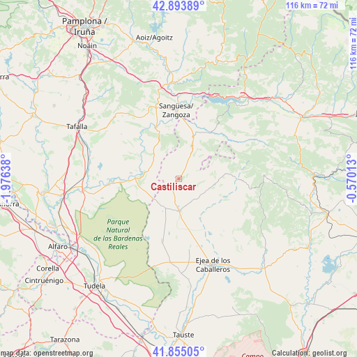
Castiliscar GPS coordinates[2]
42° 22' 35.832" North, 1° 16' 23.736" West
| Map corner | latitude | longitude |
|---|---|---|
| Upper-left | 42.89389°, | -1.97638° |
| Center: | 42.37662°, | -1.27326° |
| Lower-right: | 41.85505°, | -0.57013° |
| Map W x H: | 115.5×115.5 km | = 71.8×71.8mi |
| max Lat: | 43.74134° ⇑16% North |
| Castiliscar: | 42.37662° |
| min Lat: | ⇓84% South 27.64134° |
| min Long | Castiliscar | max Long |
| -18.00367° | -1.27326° | 4.2899° |
| W 75%⇐ | ⇒25% E |
Elevation
Elevation of Castiliscar is 491 m = 1611 ft, and this is 107 m = 351 ft below average elevation for this country.
| Max E: |
1682 m = 5518 ft | 62.6% |
| Avg. | 598 m = 1962 ft | |
| Castiliscar | 491 m = 1611 ft | |
Min E: |
0 m = 0 ft | 37.4% |
See also: Spain elevation on elevation.city.
Geographical zone
Castiliscar is located in North temperate zone (between Tropic of Cancer and the Arctic Circle). Distance of this Northern Tropic circle is 2105.9 km =1308.5 mi to South.| Distance of | km | miles | from Castiliscar |
|---|---|---|---|
| North Pole | 5295.2 | 3290.3 | to North |
| Arctic Circle | 2689.3 | 1671.1 | to North |
| Tropic Cancer | 2105.9 | 1308.5 | to South |
| Equator | 4711.8 | 2927.8 | to South |


Nearby cities:
15 places around Castiliscar: (largest is in red/bold)
• Asin
21.3 km =13.2 mi,  119°
119°
• Biota
14.6 km =9.1 mi,  150°
150°
• Carcastillo
14 km =8.7 mi,  271°
271°
• Cáseda
17.9 km =11.1 mi,  334°
334°
• Gallipienzo
20 km =12.4 mi, 325°
• Isuerre
21.8 km =13.5 mi,  55°
55°
• Layana
9.3 km =5.8 mi,  165°
165°
• Luesia
20.5 km =12.7 mi,  92°
92°
• Murillo el Fruto
15.5 km =9.6 mi,  276°
276°
• Navardún
18.3 km =11.4 mi,  34°
34°
• Petilla de Aragón
15.2 km =9.4 mi, 57°
• Sos del Rey Católico
14.2 km =8.8 mi,  19°
19°
• Sádaba
10.5 km =6.5 mi,  178°
178°
• Uncastillo
12 km =7.5 mi,  99°
99°
• Urriés
19.7 km =12.2 mi,  36°
36°
Sources, notices
• [Note1] Compared only with cities in Spain existing in our database
• [Src1] Map data: © OpenStreetMap contributors (CC-BY-SA)
• [Src2] Other city data from geonames.org with taken over terms of usage.
• [Src3] Geographical zone / Annual Mean Temperature by Robert A. Rohde @ Wikipedia
