Uña geodata
Uña (Castille-La Mancha) is a seat of a third-order administrative division; located in Spain in Europe/Madrid (GMT+2) time zone. With population of 138 people, there are 5518 cities with bigger population in this country. Compared to other cities in Spain, 66.8% of cities are located further ↑North; 67.8% of cities are located further ←West and 95.1% of cities have lower elevation than Uña. Note1


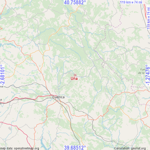
Uña GPS coordinates[2]
40° 13' 26.76" North, 1° 58' 40.368" West
| Map corner | latitude | longitude |
|---|---|---|
| Upper-left | 40.75882°, | -2.68101° |
| Center: | 40.2241°, | -1.97788° |
| Lower-right: | 39.68512°, | -1.27476° |
| Map W x H: | 119.4×119.4 km | = 74.2×74.2mi |
| max Lat: | 43.74134° ⇑66.8% North |
| Uña: | 40.2241° |
| min Lat: | ⇓33.2% South 27.64134° |
| min Long | Uña | max Long |
| -18.00367° | -1.97788° | 4.2899° |
| W 67.8%⇐ | ⇒32.2% E |
Elevation
Elevation of Uña is 1140 m = 3740 ft, and this is 542 m = 1778 ft above average elevation for this country.
| Max E: |
1682 m = 5518 ft | 4.9% |
| Uña | 1140 m 3740 ft | |
| Avg. | 598 m = 1962 ft | |
Min E: |
0 m = 0 ft | 95.1% |
See also: Spain elevation on elevation.city.
Geographical zone
Uña is located in North temperate zone (between Tropic of Cancer and the Arctic Circle). Distance of this Northern Tropic circle is 1866.6 km =1159.9 mi to South.| Distance of | km | miles | from Uña |
|---|---|---|---|
| North Pole | 5534.6 | 3439 | to North |
| Arctic Circle | 2928.7 | 1819.8 | to North |
| Tropic Cancer | 1866.6 | 1159.9 | to South |
| Equator | 4472.5 | 2779.1 | to South |


Nearby cities:
15 places around Uña: (largest is in red/bold)
• Arcos de la Sierra
17.8 km =11.1 mi,  319°
319°
• Bascuñana de San Pedro
21.3 km =13.2 mi,  266°
266°
• Beamud
13.3 km =8.3 mi,  108°
108°
• Castillejo-Sierra
21.7 km =13.5 mi, 320°
• Chillarón de Cuenca
24.6 km =15.3 mi,  237°
237°
• Cuenca
21.9 km =13.6 mi,  217°
217°
• Fresneda de la Sierra
23.2 km =14.4 mi, 323°
• Huélamo
15.4 km =9.6 mi,  67°
67°
• Mariana
15.6 km =9.7 mi,  246°
246°
• Portilla
11.4 km =7.1 mi,  309°
309°
• Valdemeca
19.9 km =12.4 mi,  90°
90°
• Valdemoro-Sierra
22.6 km =14 mi,  127°
127°
• Vega del Codorno
23 km =14.3 mi,  13°
13°
• Villalba de la Sierra
9.5 km =5.9 mi,  276°
276°
• Zarzuela
11.9 km =7.4 mi,  289°
289°
Sources, notices
• [Note1] Compared only with cities in Spain existing in our database
• [Src1] Map data: © OpenStreetMap contributors (CC-BY-SA)
• [Src2] Other city data from geonames.org with taken over terms of usage.
• [Src3] Geographical zone / Annual Mean Temperature by Robert A. Rohde @ Wikipedia
