Trasobares geodata
Trasobares (Aragon) is a seat of a third-order administrative division; located in Spain in Europe/Madrid (GMT+2) time zone. With population of 175 people, there are 5220 cities with bigger population in this country. Compared to other cities in Spain, 64.6% of cities are located further ↓South; 71.5% of cities are located further ←West and 51.5% of cities have lower elevation than Trasobares. Note1


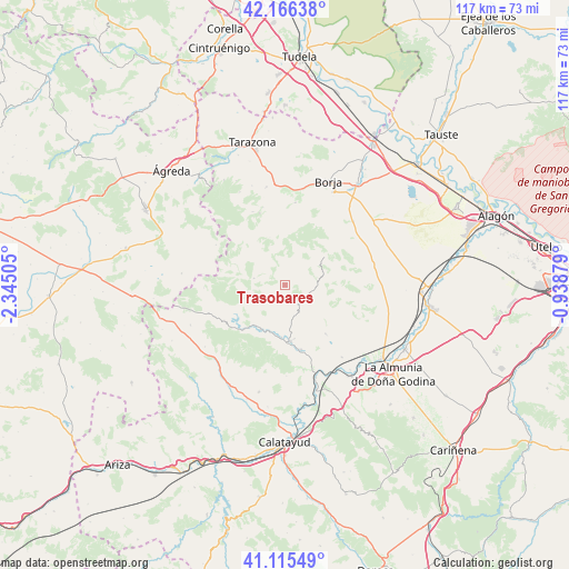
Trasobares GPS coordinates[2]
41° 38' 35.088" North, 1° 38' 30.912" West
| Map corner | latitude | longitude |
|---|---|---|
| Upper-left | 42.16638°, | -2.34505° |
| Center: | 41.64308°, | -1.64192° |
| Lower-right: | 41.11549°, | -0.93879° |
| Map W x H: | 116.8×116.8 km | = 72.6×72.6mi |
| max Lat: | 43.74134° ⇑35.4% North |
| Trasobares: | 41.64308° |
| min Lat: | ⇓64.6% South 27.64134° |
| min Long | Trasobares | max Long |
| -18.00367° | -1.64192° | 4.2899° |
| W 71.5%⇐ | ⇒28.5% E |
Elevation
Elevation of Trasobares is 674 m = 2211 ft, and this is 76 m = 249 ft above average elevation for this country.
| Max E: |
1682 m = 5518 ft | 48.5% |
| Trasobares | 674 m 2211 ft | |
| Avg. | 598 m = 1962 ft | |
Min E: |
0 m = 0 ft | 51.5% |
See also: Spain elevation on elevation.city.
Geographical zone
Trasobares is located in North temperate zone (between Tropic of Cancer and the Arctic Circle). Distance of this Northern Tropic circle is 2024.4 km =1257.9 mi to South.| Distance of | km | miles | from Trasobares |
|---|---|---|---|
| North Pole | 5376.8 | 3341 | to North |
| Arctic Circle | 2770.9 | 1721.8 | to North |
| Tropic Cancer | 2024.4 | 1257.9 | to South |
| Equator | 4630.3 | 2877.1 | to South |


Nearby cities:
15 places around Trasobares: (largest is in red/bold)
• Alcalá de Moncayo
16.5 km =10.3 mi,  344°
344°
• Aranda de Moncayo
14.4 km =8.9 mi,  239°
239°
• Beratón
16.3 km =10.1 mi,  300°
300°
• Brea de Aragón
13.7 km =8.5 mi,  166°
166°
• Calcena
6.4 km =4 mi,  282°
282°
• Gotor
10.8 km =6.7 mi,  183°
183°
• Illueca
11.7 km =7.3 mi, 174°
• Jarque
10.1 km =6.3 mi,  196°
196°
• Mesones de Isuela
13.4 km =8.3 mi,  139°
139°
• Nigüella
15.4 km =9.6 mi, 140°
• Oseja
7.2 km =4.5 mi,  222°
222°
• Pomer
16.6 km =10.3 mi,  267°
267°
• Purujosa
11.1 km =6.9 mi,  293°
293°
• Tabuenca
10 km =6.2 mi,  54°
54°
• Talamantes
10.2 km =6.3 mi, 342°
Sources, notices
• [Note1] Compared only with cities in Spain existing in our database
• [Src1] Map data: © OpenStreetMap contributors (CC-BY-SA)
• [Src2] Other city data from geonames.org with taken over terms of usage.
• [Src3] Geographical zone / Annual Mean Temperature by Robert A. Rohde @ Wikipedia
