Beratón geodata
Beratón (Castille and León) is a seat of a third-order administrative division; located in Spain in Europe/Madrid (GMT+2) time zone. With population of 47 people, there are 6495 cities with bigger population in this country. Compared to other cities in Spain, 66.5% of cities are located further ↓South; 69.3% of cities are located further ←West and 99.4% of cities have lower elevation than Beratón. Note1


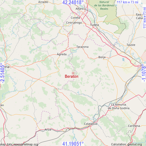
Beratón GPS coordinates[2]
41° 43' 2.964" North, 1° 48' 39.312" West
| Map corner | latitude | longitude |
|---|---|---|
| Upper-left | 42.24018°, | -2.51405° |
| Center: | 41.71749°, | -1.81092° |
| Lower-right: | 41.19051°, | -1.1078° |
| Map W x H: | 116.7×116.7 km | = 72.5×72.5mi |
| max Lat: | 43.74134° ⇑33.5% North |
| Beratón: | 41.71749° |
| min Lat: | ⇓66.5% South 27.64134° |
| min Long | Beratón | max Long |
| -18.00367° | -1.81092° | 4.2899° |
| W 69.3%⇐ | ⇒30.7% E |
Elevation
Elevation of Beratón is 1392 m = 4567 ft, and this is 794 m = 2605 ft above average elevation for this country.
| Max E: |
1682 m = 5518 ft | 0.59999999999999% |
| Beratón | 1392 m 4567 ft | |
| Avg. | 598 m = 1962 ft | |
Min E: |
0 m = 0 ft | 99.4% |
See also: Spain elevation on elevation.city.
Geographical zone
Beratón is located in North temperate zone (between Tropic of Cancer and the Arctic Circle). Distance of this Northern Tropic circle is 2032.6 km =1263 mi to South.| Distance of | km | miles | from Beratón |
|---|---|---|---|
| North Pole | 5368.5 | 3335.8 | to North |
| Arctic Circle | 2762.6 | 1716.6 | to North |
| Tropic Cancer | 2032.6 | 1263 | to South |
| Equator | 4638.6 | 2882.3 | to South |


Nearby cities:
15 places around Beratón: (largest is in red/bold)
• Alcalá de Moncayo
12.2 km =7.6 mi,  51°
51°
• Aranda de Moncayo
15.6 km =9.7 mi,  174°
174°
• Borobia
9.2 km =5.7 mi,  230°
230°
• Calcena
10.4 km =6.5 mi,  131°
131°
• Cueva de Ágreda
8.2 km =5.1 mi,  308°
308°
• Litago
11.8 km =7.3 mi,  24°
24°
• Lituénigo
13.7 km =8.5 mi, 17°
• Olvega
15.9 km =9.9 mi,  295°
295°
• Pomer
9.2 km =5.7 mi,  195°
195°
• Purujosa
5.4 km =3.4 mi,  135°
135°
• Talamantes
11.1 km =6.9 mi,  82°
82°
• Trasmoz
14.1 km =8.8 mi,  31°
31°
• Trasobares
16.3 km =10.1 mi,  120°
120°
• Vera de Moncayo
15.6 km =9.7 mi,  40°
40°
• Vozmediano
13.9 km =8.6 mi,  344°
344°
Sources, notices
• [Note1] Compared only with cities in Spain existing in our database
• [Src1] Map data: © OpenStreetMap contributors (CC-BY-SA)
• [Src2] Other city data from geonames.org with taken over terms of usage.
• [Src3] Geographical zone / Annual Mean Temperature by Robert A. Rohde @ Wikipedia
