Calcena geodata
Calcena (Aragon) is a seat of a third-order administrative division; located in Spain in Europe/Madrid (GMT+2) time zone. With population of 66 people, there are 6282 cities with bigger population in this country. Compared to other cities in Spain, 64.9% of cities are located further ↓South; 70.4% of cities are located further ←West and 72.5% of cities have lower elevation than Calcena. Note1


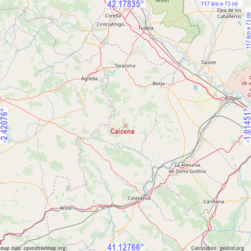
Calcena GPS coordinates[2]
41° 39' 18.54" North, 1° 43' 3.504" West
| Map corner | latitude | longitude |
|---|---|---|
| Upper-left | 42.17835°, | -2.42076° |
| Center: | 41.65515°, | -1.71764° |
| Lower-right: | 41.12766°, | -1.01451° |
| Map W x H: | 116.8×116.8 km | = 72.6×72.6mi |
| max Lat: | 43.74134° ⇑35.1% North |
| Calcena: | 41.65515° |
| min Lat: | ⇓64.9% South 27.64134° |
| min Long | Calcena | max Long |
| -18.00367° | -1.71764° | 4.2899° |
| W 70.4%⇐ | ⇒29.6% E |
Elevation
Elevation of Calcena is 830 m = 2723 ft, and this is 232 m = 761 ft above average elevation for this country.
| Max E: |
1682 m = 5518 ft | 27.5% |
| Calcena | 830 m 2723 ft | |
| Avg. | 598 m = 1962 ft | |
Min E: |
0 m = 0 ft | 72.5% |
See also: Spain elevation on elevation.city.
Geographical zone
Calcena is located in North temperate zone (between Tropic of Cancer and the Arctic Circle). Distance of this Northern Tropic circle is 2025.7 km =1258.7 mi to South.| Distance of | km | miles | from Calcena |
|---|---|---|---|
| North Pole | 5375.4 | 3340.1 | to North |
| Arctic Circle | 2769.6 | 1720.9 | to North |
| Tropic Cancer | 2025.7 | 1258.7 | to South |
| Equator | 4631.6 | 2877.9 | to South |


Nearby cities:
15 places around Calcena: (largest is in red/bold)
• Alcalá de Moncayo
14.7 km =9.1 mi,  7°
7°
• Aranda de Moncayo
10.6 km =6.6 mi,  215°
215°
• Beratón
10.4 km =6.5 mi,  311°
311°
• Borobia
14.9 km =9.3 mi,  274°
274°
• Clarés de Ribota
17.2 km =10.7 mi, 215°
• Gotor
13.4 km =8.3 mi,  154°
154°
• Illueca
15 km =9.3 mi, 150°
• Jarque
11.6 km =7.2 mi,  162°
162°
• Malanquilla
16.2 km =10.1 mi,  233°
233°
• Oseja
6.8 km =4.2 mi,  167°
167°
• Pomer
10.4 km =6.5 mi,  259°
259°
• Purujosa
5 km =3.1 mi, 307°
• Tabuenca
15.1 km =9.4 mi,  72°
72°
• Talamantes
9 km =5.6 mi,  21°
21°
• Trasobares
6.4 km =4 mi,  102°
102°
Sources, notices
• [Note1] Compared only with cities in Spain existing in our database
• [Src1] Map data: © OpenStreetMap contributors (CC-BY-SA)
• [Src2] Other city data from geonames.org with taken over terms of usage.
• [Src3] Geographical zone / Annual Mean Temperature by Robert A. Rohde @ Wikipedia
