Talamantes geodata
Talamantes (Aragon) is a seat of a third-order administrative division; located in Spain in Europe/Madrid (GMT+2) time zone. With population of 70 people, there are 6241 cities with bigger population in this country. Compared to other cities in Spain, 66.8% of cities are located further ↓South; 71% of cities are located further ←West and 78.2% of cities have lower elevation than Talamantes. Note1


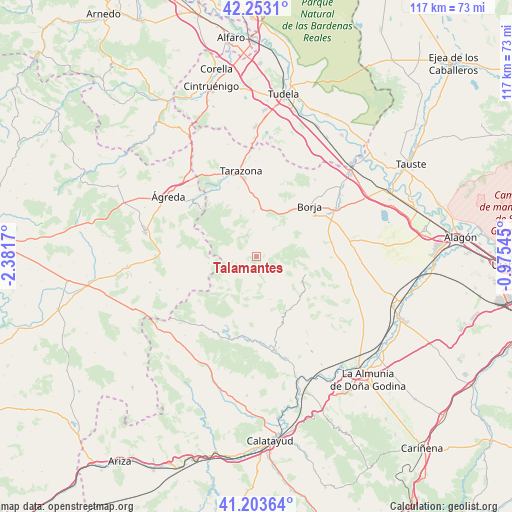
Talamantes GPS coordinates[2]
41° 43' 49.836" North, 1° 40' 42.852" West
| Map corner | latitude | longitude |
|---|---|---|
| Upper-left | 42.2531°, | -2.3817° |
| Center: | 41.73051°, | -1.67857° |
| Lower-right: | 41.20364°, | -0.97545° |
| Map W x H: | 116.7×116.7 km | = 72.5×72.5mi |
| max Lat: | 43.74134° ⇑33.2% North |
| Talamantes: | 41.73051° |
| min Lat: | ⇓66.8% South 27.64134° |
| min Long | Talamantes | max Long |
| -18.00367° | -1.67857° | 4.2899° |
| W 71%⇐ | ⇒29% E |
Elevation
Elevation of Talamantes is 881 m = 2890 ft, and this is 283 m = 928 ft above average elevation for this country.
| Max E: |
1682 m = 5518 ft | 21.8% |
| Talamantes | 881 m 2890 ft | |
| Avg. | 598 m = 1962 ft | |
Min E: |
0 m = 0 ft | 78.2% |
See also: Spain elevation on elevation.city.
Geographical zone
Talamantes is located in North temperate zone (between Tropic of Cancer and the Arctic Circle). Distance of this Northern Tropic circle is 2034.1 km =1263.9 mi to South.| Distance of | km | miles | from Talamantes |
|---|---|---|---|
| North Pole | 5367.1 | 3335 | to North |
| Arctic Circle | 2761.2 | 1715.7 | to North |
| Tropic Cancer | 2034.1 | 1263.9 | to South |
| Equator | 4640 | 2883.2 | to South |


Nearby cities:
15 places around Talamantes: (largest is in red/bold)
• Alcalá de Moncayo
6.3 km =3.9 mi,  347°
347°
• Ambel
8.9 km =5.5 mi,  36°
36°
• Beratón
11.1 km =6.9 mi,  262°
262°
• Bulbuente
11.8 km =7.3 mi,  32°
32°
• Calcena
9 km =5.6 mi,  201°
201°
• Grisel
16.2 km =10.1 mi, 345°
• Litago
11.1 km =6.9 mi,  326°
326°
• Lituénigo
13.6 km =8.5 mi, 329°
• Maleján
15.2 km =9.4 mi, 44°
• Oseja
15.1 km =9.4 mi,  186°
186°
• Purujosa
8.9 km =5.5 mi,  233°
233°
• Tabuenca
11.9 km =7.4 mi,  109°
109°
• Trasmoz
11.2 km =7 mi,  340°
340°
• Trasobares
10.2 km =6.3 mi,  162°
162°
• Vera de Moncayo
10.4 km =6.5 mi,  355°
355°
Sources, notices
• [Note1] Compared only with cities in Spain existing in our database
• [Src1] Map data: © OpenStreetMap contributors (CC-BY-SA)
• [Src2] Other city data from geonames.org with taken over terms of usage.
• [Src3] Geographical zone / Annual Mean Temperature by Robert A. Rohde @ Wikipedia
