Tortosa geodata
Tortosa (Catalonia) is a seat of a third-order administrative division; located in Spain in Europe/Madrid (GMT+2) time zone. With population of 35,143 people, there are 256 cities with bigger population in this country. Compared to other cities in Spain, 55.9% of cities are located further ↑North; 89.1% of cities are located further ←West and 96.4% of cities have higher elevation than Tortosa. Note1


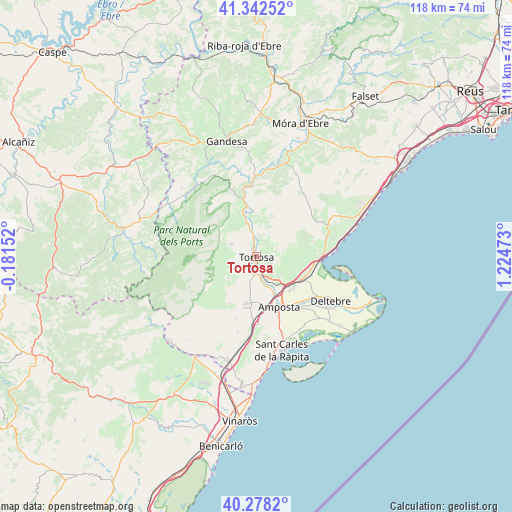
Tortosa GPS coordinates[2]
40° 48' 44.964" North, 0° 31' 17.76" East
| Map corner | latitude | longitude |
|---|---|---|
| Upper-left | 41.34252°, | -0.18152° |
| Center: | 40.81249°, | 0.5216° |
| Lower-right: | 40.2782°, | 1.22473° |
| Map W x H: | 118.3×118.3 km | = 73.5×73.5mi |
| max Lat: | 43.74134° ⇑55.9% North |
| Tortosa: | 40.81249° |
| min Lat: | ⇓44.1% South 27.64134° |
| min Long | Tortosa | max Long |
| -18.00367° | 0.5216° | 4.2899° |
| W 89.1%⇐ | ⇒10.9% E |
Elevation
Elevation of Tortosa is 18 m = 59 ft, and this is 580 m = 1903 ft below average elevation for this country.
| Max E: |
1682 m = 5518 ft | 96.4% |
| Avg. | 598 m = 1962 ft | |
| Tortosa | 18 m = 59 ft | |
Min E: |
0 m = 0 ft | 3.6% |
See also: Spain elevation on elevation.city.
Geographical zone
Tortosa is located in North temperate zone (between Tropic of Cancer and the Arctic Circle). Distance of this Northern Tropic circle is 1932 km =1200.5 mi to South.| Distance of | km | miles | from Tortosa |
|---|---|---|---|
| North Pole | 5469.1 | 3398.3 | to North |
| Arctic Circle | 2863.3 | 1779.2 | to North |
| Tropic Cancer | 1932 | 1200.5 | to South |
| Equator | 4537.9 | 2819.7 | to South |


Nearby cities:
15 places around Tortosa: (largest is in red/bold)
• Aldover
7.7 km =4.8 mi,  346°
346°
• Amposta
12.4 km =7.7 mi,  157°
157°
• Benifallet
18 km =11.2 mi,  358°
358°
• Camarles
11.7 km =7.3 mi,  106°
106°
• Deltebre
18.8 km =11.7 mi,  123°
123°
• El Perelló
17.4 km =10.8 mi,  66°
66°
• Godall
18.1 km =11.2 mi,  194°
194°
• L'Ampolla
15.9 km =9.9 mi,  90°
90°
• La Galera
15.4 km =9.6 mi,  198°
198°
• Mas de Barberans
15.7 km =9.8 mi,  235°
235°
• Masdenverge
10.8 km =6.7 mi,  176°
176°
• Paüls
15.5 km =9.6 mi,  318°
318°
• Rasquera
22.1 km =13.7 mi,  17°
17°
• Santa Bárbara
11.1 km =6.9 mi, 192°
• Tivenys
10.6 km =6.6 mi, 355°
Sources, notices
• [Note1] Compared only with cities in Spain existing in our database
• [Src1] Map data: © OpenStreetMap contributors (CC-BY-SA)
• [Src2] Other city data from geonames.org with taken over terms of usage.
• [Src3] Geographical zone / Annual Mean Temperature by Robert A. Rohde @ Wikipedia
