Benifallet geodata
Benifallet (Catalonia) is a seat of a third-order administrative division; located in Spain in Europe/Madrid (GMT+2) time zone. With population of 804 people, there are 3199 cities with bigger population in this country. Compared to other cities in Spain, 52.2% of cities are located further ↑North; 89.1% of cities are located further ←West and 95.4% of cities have higher elevation than Benifallet. Note1


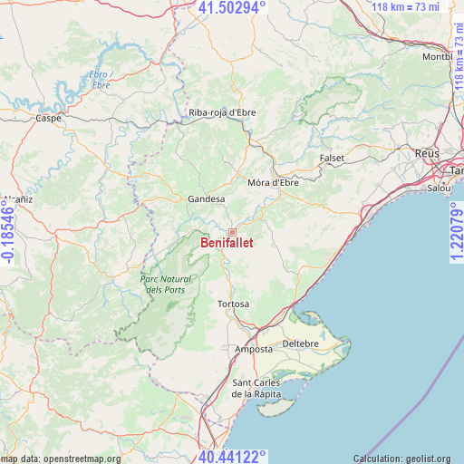
Benifallet GPS coordinates[2]
40° 58' 27.192" North, 0° 31' 3.612" East
| Map corner | latitude | longitude |
|---|---|---|
| Upper-left | 41.50294°, | -0.18546° |
| Center: | 40.97422°, | 0.51767° |
| Lower-right: | 40.44122°, | 1.22079° |
| Map W x H: | 118.1×118.1 km | = 73.4×73.4mi |
| max Lat: | 43.74134° ⇑52.2% North |
| Benifallet: | 40.97422° |
| min Lat: | ⇓47.8% South 27.64134° |
| min Long | Benifallet | max Long |
| -18.00367° | 0.51767° | 4.2899° |
| W 89.1%⇐ | ⇒10.9% E |
Elevation
Elevation of Benifallet is 23 m = 75 ft, and this is 575 m = 1886 ft below average elevation for this country.
| Max E: |
1682 m = 5518 ft | 95.4% |
| Avg. | 598 m = 1962 ft | |
| Benifallet | 23 m = 75 ft | |
Min E: |
0 m = 0 ft | 4.6% |
See also: Spain elevation on elevation.city.
Geographical zone
Benifallet is located in North temperate zone (between Tropic of Cancer and the Arctic Circle). Distance of this Northern Tropic circle is 1950 km =1211.7 mi to South.| Distance of | km | miles | from Benifallet |
|---|---|---|---|
| North Pole | 5451.2 | 3387.2 | to North |
| Arctic Circle | 2845.3 | 1768 | to North |
| Tropic Cancer | 1950 | 1211.7 | to South |
| Equator | 4555.9 | 2830.9 | to South |


Nearby cities:
15 places around Benifallet: (largest is in red/bold)
• Aldover
10.6 km =6.6 mi,  188°
188°
• Arenys de Lledó / Arens de Lledó
20.8 km =12.9 mi,  275°
275°
• Bot
11.9 km =7.4 mi,  289°
289°
• El Perelló
19.7 km =12.2 mi,  124°
124°
• Gandesa
11.1 km =6.9 mi,  323°
323°
• Ginestar
12.2 km =7.6 mi,  52°
52°
• Horta de Sant Joan
17.1 km =10.6 mi,  260°
260°
• Lledó
20.3 km =12.6 mi, 263°
• Miravet
9.8 km =6.1 mi,  42°
42°
• Paüls
11.8 km =7.3 mi,  237°
237°
• Rasquera
7.6 km =4.7 mi,  65°
65°
• Tivenys
7.4 km =4.6 mi,  183°
183°
• Tivissa
19.3 km =12 mi, 70°
• Tortosa
18 km =11.2 mi, 178°
• Vilalba dels Arcs
18 km =11.2 mi,  331°
331°
Sources, notices
• [Note1] Compared only with cities in Spain existing in our database
• [Src1] Map data: © OpenStreetMap contributors (CC-BY-SA)
• [Src2] Other city data from geonames.org with taken over terms of usage.
• [Src3] Geographical zone / Annual Mean Temperature by Robert A. Rohde @ Wikipedia
