Rasquera geodata
Rasquera (Catalonia) is a seat of a third-order administrative division; located in Spain in Europe/Madrid (GMT+2) time zone. With population of 868 people, there are 3107 cities with bigger population in this country. Compared to other cities in Spain, 51.5% of cities are located further ↑North; 89.4% of cities are located further ←West and 82.5% of cities have higher elevation than Rasquera. Note1


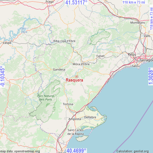
Rasquera GPS coordinates[2]
41° 0' 9.612" North, 0° 35' 58.812" East
| Map corner | latitude | longitude |
|---|---|---|
| Upper-left | 41.53117°, | -0.10345° |
| Center: | 41.00267°, | 0.59967° |
| Lower-right: | 40.4699°, | 1.3028° |
| Map W x H: | 118×118 km | = 73.3×73.3mi |
| max Lat: | 43.74134° ⇑51.5% North |
| Rasquera: | 41.00267° |
| min Lat: | ⇓48.5% South 27.64134° |
| min Long | Rasquera | max Long |
| -18.00367° | 0.59967° | 4.2899° |
| W 89.4%⇐ | ⇒10.6% E |
Elevation
Elevation of Rasquera is 176 m = 577 ft, and this is 422 m = 1385 ft below average elevation for this country.
| Max E: |
1682 m = 5518 ft | 82.5% |
| Avg. | 598 m = 1962 ft | |
| Rasquera | 176 m = 577 ft | |
Min E: |
0 m = 0 ft | 17.5% |
See also: Spain elevation on elevation.city.
Geographical zone
Rasquera is located in North temperate zone (between Tropic of Cancer and the Arctic Circle). Distance of this Northern Tropic circle is 1953.2 km =1213.7 mi to South.| Distance of | km | miles | from Rasquera |
|---|---|---|---|
| North Pole | 5448 | 3385.2 | to North |
| Arctic Circle | 2842.1 | 1766 | to North |
| Tropic Cancer | 1953.2 | 1213.7 | to South |
| Equator | 4559.1 | 2832.9 | to South |


Nearby cities:
15 places around Rasquera: (largest is in red/bold)
• Aldover
16.1 km =10 mi,  211°
211°
• Ascó
20.3 km =12.6 mi,  352°
352°
• Benifallet
7.6 km =4.7 mi,  245°
245°
• Bot
18.1 km =11.2 mi,  272°
272°
• El Perelló
17.1 km =10.6 mi,  146°
146°
• Gandesa
14.7 km =9.1 mi,  292°
292°
• Garcia
15.1 km =9.4 mi,  16°
16°
• Ginestar
5.2 km =3.2 mi,  32°
32°
• Miravet
4.1 km =2.5 mi,  356°
356°
• Paüls
19.3 km =12 mi,  240°
240°
• Tivenys
12.8 km =8 mi, 214°
• Tivissa
11.7 km =7.3 mi,  73°
73°
• Vilalba dels Arcs
19.9 km =12.4 mi,  309°
309°
• el Masroig
18.3 km =11.4 mi,  37°
37°
• l'Ametlla de Mar
20.3 km =12.6 mi,  124°
124°
Sources, notices
• [Note1] Compared only with cities in Spain existing in our database
• [Src1] Map data: © OpenStreetMap contributors (CC-BY-SA)
• [Src2] Other city data from geonames.org with taken over terms of usage.
• [Src3] Geographical zone / Annual Mean Temperature by Robert A. Rohde @ Wikipedia
