Godall geodata
Godall (Catalonia) is a populated place; located in Spain in Europe/Madrid (GMT+2) time zone. With population of 736 people, there are 3334 cities with bigger population in this country. Compared to other cities in Spain, 58.8% of cities are located further ↑North; 88.8% of cities are located further ←West and 82.5% of cities have higher elevation than Godall. Note1


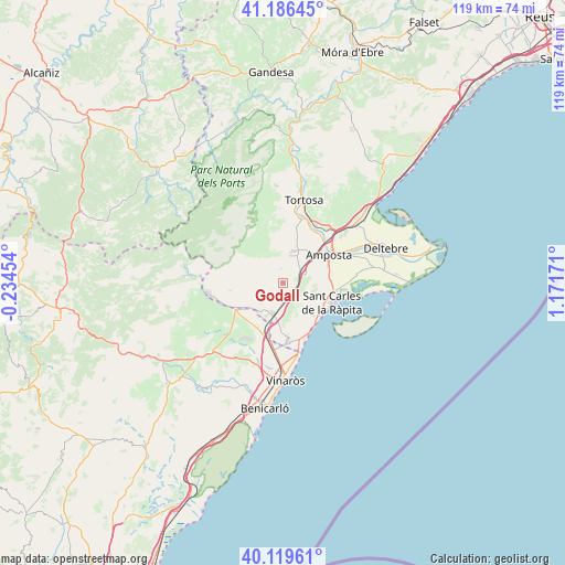
Godall GPS coordinates[2]
40° 39' 18.576" North, 0° 28' 6.888" East
| Map corner | latitude | longitude |
|---|---|---|
| Upper-left | 41.18645°, | -0.23454° |
| Center: | 40.65516°, | 0.46858° |
| Lower-right: | 40.11961°, | 1.17171° |
| Map W x H: | 118.6×118.6 km | = 73.7×73.7mi |
| max Lat: | 43.74134° ⇑58.8% North |
| Godall: | 40.65516° |
| min Lat: | ⇓41.2% South 27.64134° |
| min Long | Godall | max Long |
| -18.00367° | 0.46858° | 4.2899° |
| W 88.8%⇐ | ⇒11.2% E |
Elevation
Elevation of Godall is 177 m = 581 ft, and this is 421 m = 1381 ft below average elevation for this country.
| Max E: |
1682 m = 5518 ft | 82.5% |
| Avg. | 598 m = 1962 ft | |
| Godall | 177 m = 581 ft | |
Min E: |
0 m = 0 ft | 17.5% |
See also: Spain elevation on elevation.city.
Geographical zone
Godall is located in North temperate zone (between Tropic of Cancer and the Arctic Circle). Distance of this Northern Tropic circle is 1914.5 km =1189.6 mi to South.| Distance of | km | miles | from Godall |
|---|---|---|---|
| North Pole | 5486.6 | 3409.2 | to North |
| Arctic Circle | 2880.7 | 1790 | to North |
| Tropic Cancer | 1914.5 | 1189.6 | to South |
| Equator | 4520.4 | 2808.8 | to South |


Nearby cities:
15 places around Godall: (largest is in red/bold)
• Alcanar
12.5 km =7.8 mi,  175°
175°
• Amposta
11.1 km =6.9 mi,  56°
56°
• Camarles
21.1 km =13.1 mi,  48°
48°
• La Galera
3 km =1.9 mi,  351°
351°
• Les Cases d'Alcanar
12.4 km =7.7 mi,  155°
155°
• Mas de Barberans
12.2 km =7.6 mi,  315°
315°
• Masdenverge
8.5 km =5.3 mi,  37°
37°
• Sant Carles de la Ràpita
11.9 km =7.4 mi,  111°
111°
• Sant Jordi
19.8 km =12.3 mi,  215°
215°
• Sant Rafel del Maestrat
11.7 km =7.3 mi,  238°
238°
• Santa Bárbara
7 km =4.3 mi,  17°
17°
• Tortosa
18.1 km =11.2 mi,  14°
14°
• Traiguera
20.9 km =13 mi,  226°
226°
• Ulldecona
6.7 km =4.2 mi,  195°
195°
• Vinaròs
20.6 km =12.8 mi, 178°
Sources, notices
• [Note1] Compared only with cities in Spain existing in our database
• [Src1] Map data: © OpenStreetMap contributors (CC-BY-SA)
• [Src2] Other city data from geonames.org with taken over terms of usage.
• [Src3] Geographical zone / Annual Mean Temperature by Robert A. Rohde @ Wikipedia
