Torremormojón geodata
Torremormojón (Castille and León) is a seat of a third-order administrative division; located in Spain in Europe/Madrid (GMT+2) time zone. With population of 78 people, there are 6162 cities with bigger population in this country. Compared to other cities in Spain, 72.6% of cities are located further ↓South; 69.4% of cities are located further →East and 64.4% of cities have lower elevation than Torremormojón. Note1
Administrative division(s):
- Level 1: Castille and León
- Level 2: Provincia de Palencia
- Level 3: Torremormojón


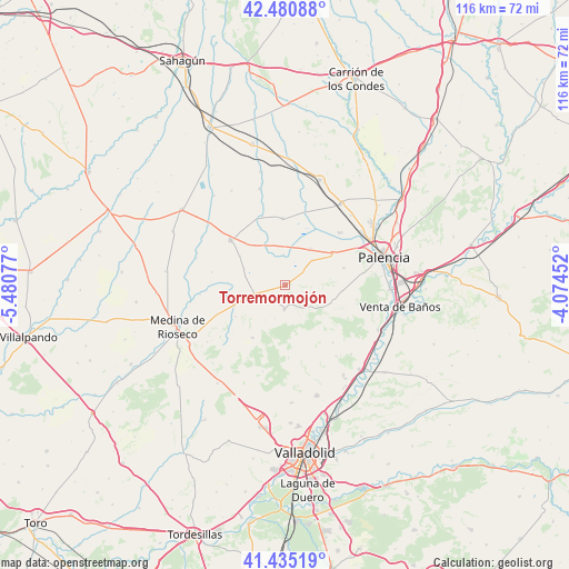
Torremormojón GPS coordinates[2]
41° 57' 36.648" North, 4° 46' 39.54" West
| Map corner | latitude | longitude |
|---|---|---|
| Upper-left | 42.48088°, | -5.48077° |
| Center: | 41.96018°, | -4.77765° |
| Lower-right: | 41.43519°, | -4.07452° |
| Map W x H: | 116.3×116.3 km | = 72.3×72.3mi |
| max Lat: | 43.74134° ⇑27.4% North |
| Torremormojón: | 41.96018° |
| min Lat: | ⇓72.6% South 27.64134° |
| min Long | Torremormojón | max Long |
| -18.00367° | -4.77765° | 4.2899° |
| W 30.6%⇐ | ⇒69.4% E |
Elevation
Elevation of Torremormojón is 774 m = 2539 ft, and this is 176 m = 577 ft above average elevation for this country.
| Max E: |
1682 m = 5518 ft | 35.6% |
| Torremormojón | 774 m 2539 ft | |
| Avg. | 598 m = 1962 ft | |
Min E: |
0 m = 0 ft | 64.4% |
See also: Spain elevation on elevation.city.
Geographical zone
Torremormojón is located in North temperate zone (between Tropic of Cancer and the Arctic Circle). Distance of this Northern Tropic circle is 2059.6 km =1279.8 mi to South.| Distance of | km | miles | from Torremormojón |
|---|---|---|---|
| North Pole | 5341.5 | 3319.1 | to North |
| Arctic Circle | 2735.6 | 1699.8 | to North |
| Tropic Cancer | 2059.6 | 1279.8 | to South |
| Equator | 4665.5 | 2899 | to South |


Nearby cities:
15 places around Torremormojón: (largest is in red/bold)
• Ampudia
4.9 km =3 mi,  182°
182°
• Autilla del Pino
12.4 km =7.7 mi,  73°
73°
• Baquerín de Campos
6.2 km =3.9 mi,  356°
356°
• Boada de Campos
8.9 km =5.5 mi,  291°
291°
• Capillas
11.1 km =6.9 mi,  302°
302°
• Castromocho
8.8 km =5.5 mi,  334°
334°
• Fuentes de Nava
13.7 km =8.5 mi, 358°
• Mazariegos
9 km =5.6 mi,  34°
34°
• Meneses de Campos
11.9 km =7.4 mi,  259°
259°
• Pedraza de Campos
4.4 km =2.7 mi,  52°
52°
• Rayaces
6.8 km =4.2 mi,  129°
129°
• Santa Cecilia del Alcor
10.6 km =6.6 mi,  107°
107°
• Villalba de los Alcores
12.7 km =7.9 mi,  212°
212°
• Villamartín de Campos
11.2 km =7 mi,  56°
56°
• Villarramiel
14.4 km =8.9 mi,  309°
309°
Sources, notices
• [Note1] Compared only with cities in Spain existing in our database
• [Src1] Map data: © OpenStreetMap contributors (CC-BY-SA)
• [Src2] Other city data from geonames.org with taken over terms of usage.
• [Src3] Geographical zone / Annual Mean Temperature by Robert A. Rohde @ Wikipedia
