Villamartín de Campos geodata
Villamartín de Campos (Castille and León) is a seat of a third-order administrative division; located in Spain in Europe/Madrid (GMT+2) time zone. With population of 129 people, there are 5591 cities with bigger population in this country. Compared to other cities in Spain, 74.1% of cities are located further ↓South; 68.2% of cities are located further →East and 60.5% of cities have lower elevation than Villamartín de Campos. Note1
Administrative division(s):
- Level 1: Castille and León
- Level 2: Provincia de Palencia
- Level 3: Villamartín de Campos
Current local time in Villamartín de Campos:
11:54 PM, ThursdayDifference from your time zone: hours


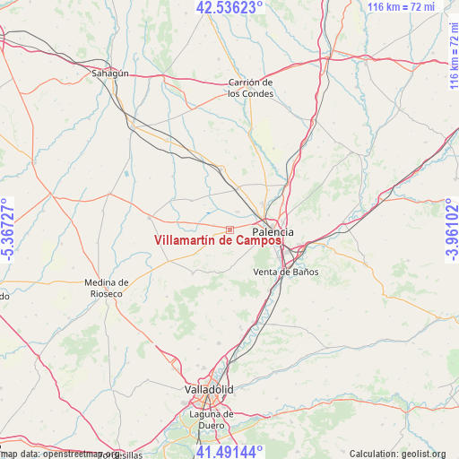
Villamartín de Campos GPS coordinates[2]
42° 0' 57.528" North, 4° 39' 50.904" West
| Map corner | latitude | longitude |
|---|---|---|
| Upper-left | 42.53623°, | -5.36727° |
| Center: | 42.01598°, | -4.66414° |
| Lower-right: | 41.49144°, | -3.96102° |
| Map W x H: | 116.2×116.2 km | = 72.2×72.2mi |
| max Lat: | 43.74134° ⇑25.9% North |
| Villamartín de Campos: | 42.01598° |
| min Lat: | ⇓74.1% South 27.64134° |
| min Long | Villamartín de | max Long |
| -18.00367° | -4.66414° | 4.2899° |
| W 31.8%⇐ | ⇒68.2% E |
Elevation
Elevation of Villamartín de Campos is 748 m = 2454 ft, and this is 150 m = 492 ft above average elevation for this country.
| Max E: |
1682 m = 5518 ft | 39.5% |
| Villamartín de Campos | 748 m 2454 ft | |
| Avg. | 598 m = 1962 ft | |
Min E: |
0 m = 0 ft | 60.5% |
See also: Spain elevation on elevation.city.
Geographical zone
Villamartín de Campos is located in North temperate zone (between Tropic of Cancer and the Arctic Circle). Distance of this Northern Tropic circle is 2065.8 km =1283.6 mi to South.| Distance of | km | miles | from Villamartín de Campos |
|---|---|---|---|
| North Pole | 5335.3 | 3315.2 | to North |
| Arctic Circle | 2729.4 | 1696 | to North |
| Tropic Cancer | 2065.8 | 1283.6 | to South |
| Equator | 4671.7 | 2902.9 | to South |


Nearby cities:
15 places around Villamartín de Campos: (largest is in red/bold)
• Autilla del Pino
3.6 km =2.2 mi,  136°
136°
• Baquerín de Campos
9.7 km =6 mi,  270°
270°
• Becerril de Campos
10.4 km =6.5 mi,  10°
10°
• Castromocho
13.3 km =8.3 mi,  277°
277°
• Fuentes de Nava
12.4 km =7.7 mi,  307°
307°
• Grijota
7.9 km =4.9 mi,  58°
58°
• Husillos
14 km =8.7 mi,  53°
53°
• Mazariegos
4.4 km =2.7 mi,  286°
286°
• Palencia
11.6 km =7.2 mi,  93°
93°
• Pedraza de Campos
6.9 km =4.3 mi,  238°
238°
• Rayaces
11.3 km =7 mi,  201°
201°
• Santa Cecilia del Alcor
9.3 km =5.8 mi,  175°
175°
• Torremormojón
11.2 km =7 mi, 236°
• Villalobón
13.4 km =8.3 mi,  83°
83°
• Villaumbrales
9.1 km =5.7 mi,  27°
27°
Sources, notices
• [Note1] Compared only with cities in Spain existing in our database
• [Src1] Map data: © OpenStreetMap contributors (CC-BY-SA)
• [Src2] Other city data from geonames.org with taken over terms of usage.
• [Src3] Geographical zone / Annual Mean Temperature by Robert A. Rohde @ Wikipedia
