Rayaces geodata
Rayaces (Castille and León) is a seat of a third-order administrative division; located in Spain in Europe/Madrid (GMT+2) time zone. In our database, there are 6762 cities with bigger population. Compared to other cities in Spain, 71.4% of cities are located further ↓South; 68.8% of cities are located further →East and 69.1% of cities have lower elevation than Rayaces. Note1
Administrative division(s):
- Level 1: Castille and León
- Level 2: Provincia de Palencia
- Level 3: Ampudia


Rayaces GPS coordinates[2]
41° 55' 16.932" North, 4° 42' 50.436" West
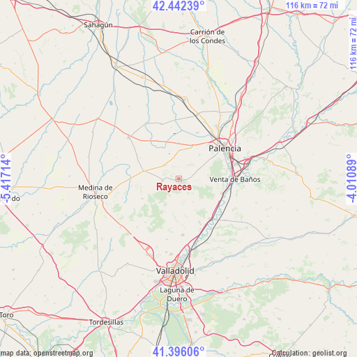
| Map corner | latitude | longitude |
|---|---|---|
| Upper-left | 42.44239°, | -5.41714° |
| Center: | 41.92137°, | -4.71401° |
| Lower-right: | 41.39606°, | -4.01089° |
| Map W x H: | 116.3×116.3 km | = 72.3×72.3mi |
| max Lat: | 43.74134° ⇑28.6% North |
| Rayaces: | 41.92137° |
| min Lat: | ⇓71.4% South 27.64134° |
| min Long | Rayaces | max Long |
| -18.00367° | -4.71401° | 4.2899° |
| W 31.2%⇐ | ⇒68.8% E |
Elevation
Elevation of Rayaces is 807 m = 2648 ft, and this is 209 m = 686 ft above average elevation for this country.
| Max E: |
1682 m = 5518 ft | 30.9% |
| Rayaces | 807 m 2648 ft | |
| Avg. | 598 m = 1962 ft | |
Min E: |
0 m = 0 ft | 69.1% |
See also: Spain elevation on elevation.city.
Geographical zone
Rayaces is located in North temperate zone (between Tropic of Cancer and the Arctic Circle). Distance of this Northern Tropic circle is 2055.3 km =1277.1 mi to South.| Distance of | km | miles | from Rayaces |
|---|---|---|---|
| North Pole | 5345.8 | 3321.7 | to North |
| Arctic Circle | 2740 | 1702.6 | to North |
| Tropic Cancer | 2055.3 | 1277.1 | to South |
| Equator | 4661.2 | 2896.3 | to South |


Nearby cities:
15 places around Rayaces: (largest is in red/bold)
• Ampudia
5.5 km =3.4 mi,  263°
263°
• Autilla del Pino
10.3 km =6.4 mi,  40°
40°
• Baquerín de Campos
11.9 km =7.4 mi,  331°
331°
• Castromocho
15.2 km =9.4 mi,  323°
323°
• Corcos
12.6 km =7.8 mi,  171°
171°
• Cubillas de Santa Marta
12.8 km =8 mi,  139°
139°
• Dueñas
14.7 km =9.1 mi,  109°
109°
• Mazariegos
11.7 km =7.3 mi,  359°
359°
• Pedraza de Campos
7.2 km =4.5 mi,  345°
345°
• Quintanilla de Trigueros
8.7 km =5.4 mi,  148°
148°
• Santa Cecilia del Alcor
5 km =3.1 mi,  75°
75°
• Torremormojón
6.8 km =4.2 mi,  309°
309°
• Trigueros del Valle
11.3 km =7 mi, 152°
• Villalba de los Alcores
13.7 km =8.5 mi,  242°
242°
• Villamartín de Campos
11.3 km =7 mi,  21°
21°
Sources, notices
• [Note1] Compared only with cities in Spain existing in our database
• [Src1] Map data: © OpenStreetMap contributors (CC-BY-SA)
• [Src2] Other city data from geonames.org with taken over terms of usage.
• [Src3] Geographical zone / Annual Mean Temperature by Robert A. Rohde @ Wikipedia
