Castromocho geodata
Castromocho (Castille and León) is a seat of a third-order administrative division; located in Spain in Europe/Madrid (GMT+2) time zone. With population of 260 people, there are 4682 cities with bigger population in this country. Compared to other cities in Spain, 74.6% of cities are located further ↓South; 69.9% of cities are located further →East and 61.9% of cities have lower elevation than Castromocho. Note1
Administrative division(s):
- Level 1: Castille and León
- Level 2: Provincia de Palencia
- Level 3: Castromocho


Castromocho GPS coordinates[2]
42° 1' 51.744" North, 4° 49' 26.544" West
| Map corner | latitude | longitude |
|---|---|---|
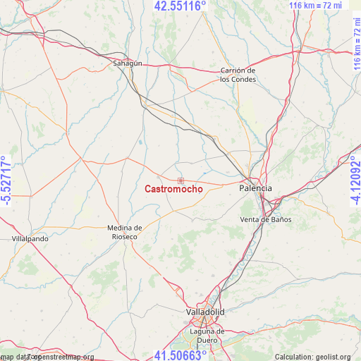
| Upper-left | 42.55116°, | -5.52717° |
| Center: | 42.03104°, | -4.82404° |
| Lower-right: | 41.50663°, | -4.12092° |
| Map W x H: | 116.1×116.1 km | = 72.1×72.1mi |
| max Lat: | 43.74134° ⇑25.4% North |
| Castromocho: | 42.03104° |
| min Lat: | ⇓74.6% South 27.64134° |
| min Long | Castromocho | max Long |
| -18.00367° | -4.82404° | 4.2899° |
| W 30.1%⇐ | ⇒69.9% E |
Elevation
Elevation of Castromocho is 756 m = 2480 ft, and this is 158 m = 518 ft above average elevation for this country.
| Max E: |
1682 m = 5518 ft | 38.1% |
| Castromocho | 756 m 2480 ft | |
| Avg. | 598 m = 1962 ft | |
Min E: |
0 m = 0 ft | 61.9% |
See also: Spain elevation on elevation.city.
Geographical zone
Castromocho is located in North temperate zone (between Tropic of Cancer and the Arctic Circle). Distance of this Northern Tropic circle is 2067.5 km =1284.7 mi to South.| Distance of | km | miles | from Castromocho |
|---|---|---|---|
| North Pole | 5333.6 | 3314.1 | to North |
| Arctic Circle | 2727.8 | 1695 | to North |
| Tropic Cancer | 2067.5 | 1284.7 | to South |
| Equator | 4673.4 | 2903.9 | to South |


Nearby cities:
15 places around Castromocho: (largest is in red/bold)
• Ampudia
13.3 km =8.3 mi,  164°
164°
• Autillo de Campos
6.3 km =3.9 mi,  352°
352°
• Baquerín de Campos
3.9 km =2.4 mi,  115°
115°
• Boada de Campos
6.4 km =4 mi,  223°
223°
• Capillas
5.8 km =3.6 mi,  250°
250°
• Castil de Vela
12.3 km =7.6 mi, 245°
• Frechilla
11.9 km =7.4 mi, 353°
• Fuentes de Nava
6.7 km =4.2 mi,  30°
30°
• Gatón de Campos
13.1 km =8.1 mi,  279°
279°
• Mazariegos
9 km =5.6 mi,  92°
92°
• Meneses de Campos
12.7 km =7.9 mi, 218°
• Pedraza de Campos
9 km =5.6 mi,  125°
125°
• Torremormojón
8.8 km =5.5 mi,  154°
154°
• Villamartín de Campos
13.3 km =8.3 mi,  97°
97°
• Villarramiel
7.4 km =4.6 mi, 280°
Sources, notices
• [Note1] Compared only with cities in Spain existing in our database
• [Src1] Map data: © OpenStreetMap contributors (CC-BY-SA)
• [Src2] Other city data from geonames.org with taken over terms of usage.
• [Src3] Geographical zone / Annual Mean Temperature by Robert A. Rohde @ Wikipedia
