Torrelapaja geodata
Torrelapaja (Aragon) is a seat of a third-order administrative division; located in Spain in Europe/Madrid (GMT+2) time zone. With population of 42 people, there are 6543 cities with bigger population in this country. Compared to other cities in Spain, 63% of cities are located further ↓South; 68% of cities are located further ←West and 87.7% of cities have lower elevation than Torrelapaja. Note1


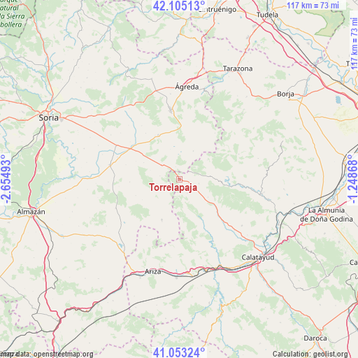
Torrelapaja GPS coordinates[2]
41° 34' 52.788" North, 1° 57' 6.516" West
| Map corner | latitude | longitude |
|---|---|---|
| Upper-left | 42.10513°, | -2.65493° |
| Center: | 41.58133°, | -1.95181° |
| Lower-right: | 41.05324°, | -1.24868° |
| Map W x H: | 117×117 km | = 72.7×72.7mi |
| max Lat: | 43.74134° ⇑37% North |
| Torrelapaja: | 41.58133° |
| min Lat: | ⇓63% South 27.64134° |
| min Long | Torrelapaja | max Long |
| -18.00367° | -1.95181° | 4.2899° |
| W 68%⇐ | ⇒32% E |
Elevation
Elevation of Torrelapaja is 992 m = 3255 ft, and this is 394 m = 1293 ft above average elevation for this country.
| Max E: |
1682 m = 5518 ft | 12.3% |
| Torrelapaja | 992 m 3255 ft | |
| Avg. | 598 m = 1962 ft | |
Min E: |
0 m = 0 ft | 87.7% |
See also: Spain elevation on elevation.city.
Geographical zone
Torrelapaja is located in North temperate zone (between Tropic of Cancer and the Arctic Circle). Distance of this Northern Tropic circle is 2017.5 km =1253.6 mi to South.| Distance of | km | miles | from Torrelapaja |
|---|---|---|---|
| North Pole | 5383.7 | 3345.3 | to North |
| Arctic Circle | 2777.8 | 1726 | to North |
| Tropic Cancer | 2017.5 | 1253.6 | to South |
| Equator | 4623.4 | 2872.8 | to South |


Nearby cities:
15 places around Torrelapaja: (largest is in red/bold)
• Aranda de Moncayo
13.3 km =8.3 mi,  91°
91°
• Berdejo
2.3 km =1.4 mi,  164°
164°
• Bijuesca
5.2 km =3.2 mi,  149°
149°
• Borobia
10.4 km =6.5 mi,  26°
26°
• Carabantes
5 km =3.1 mi,  229°
229°
• Ciria
4.3 km =2.7 mi,  344°
344°
• Clarés de Ribota
11.1 km =6.9 mi,  121°
121°
• Deza
14.3 km =8.9 mi,  203°
203°
• Malanquilla
6.6 km =4.1 mi,  102°
102°
• Noviercas
16.1 km =10 mi,  334°
334°
• Pomer
11.1 km =6.9 mi,  55°
55°
• Portillo de Soria
15.3 km =9.5 mi,  292°
292°
• Reznos
6.4 km =4 mi,  279°
279°
• Torrijo de la Cañada
13.7 km =8.5 mi, 151°
• Torrubia de Soria
12.8 km =8 mi,  295°
295°
Sources, notices
• [Note1] Compared only with cities in Spain existing in our database
• [Src1] Map data: © OpenStreetMap contributors (CC-BY-SA)
• [Src2] Other city data from geonames.org with taken over terms of usage.
• [Src3] Geographical zone / Annual Mean Temperature by Robert A. Rohde @ Wikipedia
