Borobia geodata
Borobia (Castille and León) is a seat of a third-order administrative division; located in Spain in Europe/Madrid (GMT+2) time zone. With population of 340 people, there are 4347 cities with bigger population in this country. Compared to other cities in Spain, 65.1% of cities are located further ↓South; 68.5% of cities are located further ←West and 95% of cities have lower elevation than Borobia. Note1


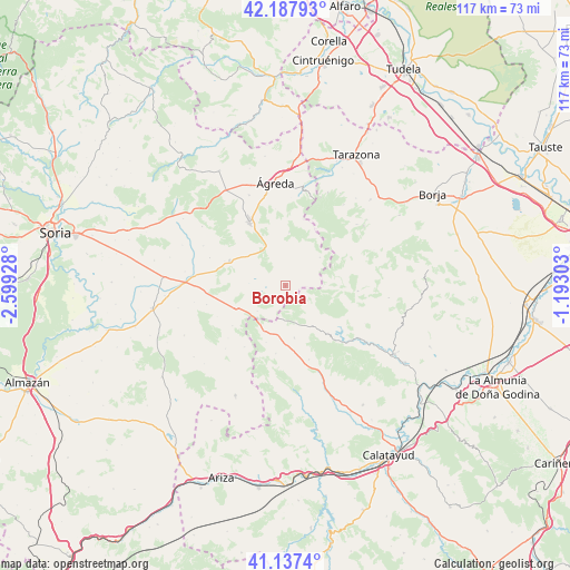
Borobia GPS coordinates[2]
41° 39' 53.316" North, 1° 53' 46.14" West
| Map corner | latitude | longitude |
|---|---|---|
| Upper-left | 42.18793°, | -2.59928° |
| Center: | 41.66481°, | -1.89615° |
| Lower-right: | 41.1374°, | -1.19303° |
| Map W x H: | 116.8×116.8 km | = 72.6×72.6mi |
| max Lat: | 43.74134° ⇑34.9% North |
| Borobia: | 41.66481° |
| min Lat: | ⇓65.1% South 27.64134° |
| min Long | Borobia | max Long |
| -18.00367° | -1.89615° | 4.2899° |
| W 68.5%⇐ | ⇒31.5% E |
Elevation
Elevation of Borobia is 1137 m = 3730 ft, and this is 539 m = 1768 ft above average elevation for this country.
| Max E: |
1682 m = 5518 ft | 5% |
| Borobia | 1137 m 3730 ft | |
| Avg. | 598 m = 1962 ft | |
Min E: |
0 m = 0 ft | 95% |
See also: Spain elevation on elevation.city.
Geographical zone
Borobia is located in North temperate zone (between Tropic of Cancer and the Arctic Circle). Distance of this Northern Tropic circle is 2026.8 km =1259.4 mi to South.| Distance of | km | miles | from Borobia |
|---|---|---|---|
| North Pole | 5374.4 | 3339.5 | to North |
| Arctic Circle | 2768.5 | 1720.3 | to North |
| Tropic Cancer | 2026.8 | 1259.4 | to South |
| Equator | 4632.7 | 2878.6 | to South |


Nearby cities:
15 places around Borobia: (largest is in red/bold)
• Aranda de Moncayo
13 km =8.1 mi,  138°
138°
• Beratón
9.2 km =5.7 mi,  50°
50°
• Berdejo
12.2 km =7.6 mi,  199°
199°
• Bijuesca
13.9 km =8.6 mi,  188°
188°
• Calcena
14.9 km =9.3 mi,  94°
94°
• Carabantes
15.1 km =9.4 mi,  214°
214°
• Ciria
7.8 km =4.8 mi,  228°
228°
• Cueva de Ágreda
10.9 km =6.8 mi,  3°
3°
• Malanquilla
10.8 km =6.7 mi,  170°
170°
• Noviercas
12.6 km =7.8 mi,  294°
294°
• Olvega
14.6 km =9.1 mi,  330°
330°
• Pomer
5.5 km =3.4 mi,  123°
123°
• Purujosa
11.1 km =6.9 mi,  79°
79°
• Reznos
13.7 km =8.5 mi, 233°
• Torrelapaja
10.4 km =6.5 mi, 206°
Sources, notices
• [Note1] Compared only with cities in Spain existing in our database
• [Src1] Map data: © OpenStreetMap contributors (CC-BY-SA)
• [Src2] Other city data from geonames.org with taken over terms of usage.
• [Src3] Geographical zone / Annual Mean Temperature by Robert A. Rohde @ Wikipedia
