Deza geodata
Deza (Castille and León) is a seat of a third-order administrative division; located in Spain in Europe/Madrid (GMT+2) time zone. With population of 343 people, there are 4335 cities with bigger population in this country. Compared to other cities in Spain, 59.9% of cities are located further ↓South; 67.3% of cities are located further ←West and 79% of cities have lower elevation than Deza. Note1


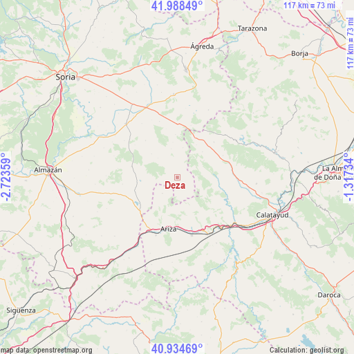
Deza GPS coordinates[2]
41° 27' 49.428" North, 2° 1' 13.656" West
| Map corner | latitude | longitude |
|---|---|---|
| Upper-left | 41.98849°, | -2.72359° |
| Center: | 41.46373°, | -2.02046° |
| Lower-right: | 40.93469°, | -1.31734° |
| Map W x H: | 117.2×117.2 km | = 72.8×72.8mi |
| max Lat: | 43.74134° ⇑40.1% North |
| Deza: | 41.46373° |
| min Lat: | ⇓59.9% South 27.64134° |
| min Long | Deza | max Long |
| -18.00367° | -2.02046° | 4.2899° |
| W 67.3%⇐ | ⇒32.7% E |
Elevation
Elevation of Deza is 889 m = 2917 ft, and this is 291 m = 955 ft above average elevation for this country.
| Max E: |
1682 m = 5518 ft | 21% |
| Deza | 889 m 2917 ft | |
| Avg. | 598 m = 1962 ft | |
Min E: |
0 m = 0 ft | 79% |
See also: Spain elevation on elevation.city.
Geographical zone
Deza is located in North temperate zone (between Tropic of Cancer and the Arctic Circle). Distance of this Northern Tropic circle is 2004.4 km =1245.5 mi to South.| Distance of | km | miles | from Deza |
|---|---|---|---|
| North Pole | 5396.7 | 3353.4 | to North |
| Arctic Circle | 2790.8 | 1734.1 | to North |
| Tropic Cancer | 2004.4 | 1245.5 | to South |
| Equator | 4610.3 | 2864.7 | to South |


Nearby cities:
15 places around Deza: (largest is in red/bold)
• Almazul
16.1 km =10 mi,  319°
319°
• Berdejo
12.6 km =7.8 mi,  30°
30°
• Bijuesca
12 km =7.5 mi,  44°
44°
• Bordalba
6.5 km =4 mi,  216°
216°
• Carabantes
10 km =6.2 mi,  10°
10°
• Cihuela
6.5 km =4 mi,  164°
164°
• Embid de Ariza
10.3 km =6.4 mi, 157°
• Malanquilla
16.8 km =10.4 mi,  46°
46°
• Monteagudo de las Vicarías
16.6 km =10.3 mi,  228°
228°
• Pozuel de Ariza
16.6 km =10.3 mi, 220°
• Reznos
14.2 km =8.8 mi,  357°
357°
• Torlengua
11.8 km =7.3 mi,  265°
265°
• Torrelapaja
14.3 km =8.9 mi,  23°
23°
• Torrijo de la Cañada
12.2 km =7.6 mi,  85°
85°
• Villalengua
15.3 km =9.5 mi,  101°
101°
Sources, notices
• [Note1] Compared only with cities in Spain existing in our database
• [Src1] Map data: © OpenStreetMap contributors (CC-BY-SA)
• [Src2] Other city data from geonames.org with taken over terms of usage.
• [Src3] Geographical zone / Annual Mean Temperature by Robert A. Rohde @ Wikipedia
