Tauste geodata
Tauste (Aragon) is a seat of a third-order administrative division; located in Spain in Europe/Madrid (GMT+2) time zone. With population of 7,334 people, there are 1001 cities with bigger population in this country. Compared to other cities in Spain, 71.3% of cities are located further ↓South; 75.2% of cities are located further ←West and 76.9% of cities have higher elevation than Tauste. Note1


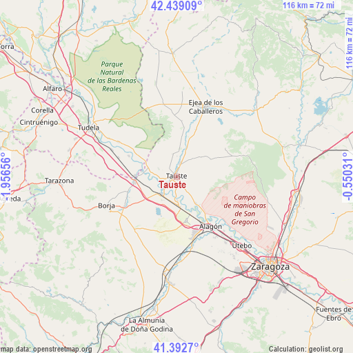
Tauste GPS coordinates[2]
41° 55' 4.944" North, 1° 15' 12.348" West
| Map corner | latitude | longitude |
|---|---|---|
| Upper-left | 42.43909°, | -1.95656° |
| Center: | 41.91804°, | -1.25343° |
| Lower-right: | 41.3927°, | -0.55031° |
| Map W x H: | 116.3×116.3 km | = 72.3×72.3mi |
| max Lat: | 43.74134° ⇑28.7% North |
| Tauste: | 41.91804° |
| min Lat: | ⇓71.3% South 27.64134° |
| min Long | Tauste | max Long |
| -18.00367° | -1.25343° | 4.2899° |
| W 75.2%⇐ | ⇒24.8% E |
Elevation
Elevation of Tauste is 272 m = 892 ft, and this is 326 m = 1070 ft below average elevation for this country.
| Max E: |
1682 m = 5518 ft | 76.9% |
| Avg. | 598 m = 1962 ft | |
| Tauste | 272 m = 892 ft | |
Min E: |
0 m = 0 ft | 23.1% |
See also: Spain elevation on elevation.city.
Geographical zone
Tauste is located in North temperate zone (between Tropic of Cancer and the Arctic Circle). Distance of this Northern Tropic circle is 2054.9 km =1276.9 mi to South.| Distance of | km | miles | from Tauste |
|---|---|---|---|
| North Pole | 5346.2 | 3322 | to North |
| Arctic Circle | 2740.3 | 1702.7 | to North |
| Tropic Cancer | 2054.9 | 1276.9 | to South |
| Equator | 4660.8 | 2896.1 | to South |


Nearby cities:
15 places around Tauste: (largest is in red/bold)
• Agón
17.9 km =11.1 mi,  247°
247°
• Alcalá de Ebro
12.5 km =7.8 mi,  156°
156°
• Bisimbre
17.1 km =10.6 mi, 246°
• Boquiñeni
7.8 km =4.8 mi,  179°
179°
• Buñuel
17.3 km =10.7 mi,  293°
293°
• Cabañas de Ebro
13.9 km =8.6 mi, 161°
• Cortes
13.8 km =8.6 mi,  272°
272°
• Fréscano
16.7 km =10.4 mi,  256°
256°
• Gallur
7.6 km =4.7 mi,  223°
223°
• Luceni
10 km =6.2 mi,  173°
173°
• Mallén
13.9 km =8.6 mi, 262°
• Novillas
11.8 km =7.3 mi,  278°
278°
• Pedrola
14.5 km =9 mi, 166°
• Pradilla de Ebro
6.4 km =4 mi,  187°
187°
• Remolinos
10.8 km =6.7 mi,  144°
144°
Sources, notices
• [Note1] Compared only with cities in Spain existing in our database
• [Src1] Map data: © OpenStreetMap contributors (CC-BY-SA)
• [Src2] Other city data from geonames.org with taken over terms of usage.
• [Src3] Geographical zone / Annual Mean Temperature by Robert A. Rohde @ Wikipedia
