Luceni geodata
Luceni (Aragon) is a seat of a third-order administrative division; located in Spain in Europe/Madrid (GMT+2) time zone. With population of 1,045 people, there are 2887 cities with bigger population in this country. Compared to other cities in Spain, 69.3% of cities are located further ↓South; 75.3% of cities are located further ←West and 79.2% of cities have higher elevation than Luceni. Note1


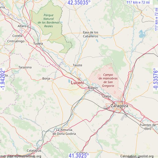
Luceni GPS coordinates[2]
41° 49' 42.852" North, 1° 14' 20.004" West
| Map corner | latitude | longitude |
|---|---|---|
| Upper-left | 42.35035°, | -1.94202° |
| Center: | 41.82857°, | -1.23889° |
| Lower-right: | 41.3025°, | -0.53576° |
| Map W x H: | 116.5×116.5 km | = 72.4×72.4mi |
| max Lat: | 43.74134° ⇑30.7% North |
| Luceni: | 41.82857° |
| min Lat: | ⇓69.3% South 27.64134° |
| min Long | Luceni | max Long |
| -18.00367° | -1.23889° | 4.2899° |
| W 75.3%⇐ | ⇒24.7% E |
Elevation
Elevation of Luceni is 235 m = 771 ft, and this is 363 m = 1191 ft below average elevation for this country.
| Max E: |
1682 m = 5518 ft | 79.2% |
| Avg. | 598 m = 1962 ft | |
| Luceni | 235 m = 771 ft | |
Min E: |
0 m = 0 ft | 20.8% |
See also: Spain elevation on elevation.city.
Geographical zone
Luceni is located in North temperate zone (between Tropic of Cancer and the Arctic Circle). Distance of this Northern Tropic circle is 2045 km =1270.7 mi to South.| Distance of | km | miles | from Luceni |
|---|---|---|---|
| North Pole | 5356.2 | 3328.2 | to North |
| Arctic Circle | 2750.3 | 1709 | to North |
| Tropic Cancer | 2045 | 1270.7 | to South |
| Equator | 4650.9 | 2889.9 | to South |


Nearby cities:
15 places around Luceni: (largest is in red/bold)
• Alagón
11.9 km =7.4 mi,  123°
123°
• Alcalá de Ebro
4 km =2.5 mi,  112°
112°
• Bardallur
16.2 km =10.1 mi,  172°
172°
• Boquiñeni
2.4 km =1.5 mi,  332°
332°
• Bárboles
14 km =8.7 mi,  161°
161°
• Cabañas de Ebro
4.5 km =2.8 mi,  134°
134°
• Figueruelas
8.7 km =5.4 mi,  142°
142°
• Gallur
7.7 km =4.8 mi,  304°
304°
• Grisén
11.2 km =7 mi,  145°
145°
• Pedrola
4.7 km =2.9 mi, 153°
• Pinseque
15.4 km =9.6 mi, 131°
• Pleitas
13.4 km =8.3 mi, 166°
• Pradilla de Ebro
4.1 km =2.5 mi, 330°
• Remolinos
5.2 km =3.2 mi,  76°
76°
• Tauste
10 km =6.2 mi,  353°
353°
Sources, notices
• [Note1] Compared only with cities in Spain existing in our database
• [Src1] Map data: © OpenStreetMap contributors (CC-BY-SA)
• [Src2] Other city data from geonames.org with taken over terms of usage.
• [Src3] Geographical zone / Annual Mean Temperature by Robert A. Rohde @ Wikipedia
