Tamarón geodata
Tamarón (Castille and León) is a seat of a third-order administrative division; located in Spain in Europe/Madrid (GMT+2) time zone. With population of 43 people, there are 6531 cities with bigger population in this country. Compared to other cities in Spain, 81.2% of cities are located further ↓South; 59.6% of cities are located further →East and 70.9% of cities have lower elevation than Tamarón. Note1
Administrative division(s):
- Level 1: Castille and León
- Level 2: Provincia de Burgos
- Level 3: Tamarón


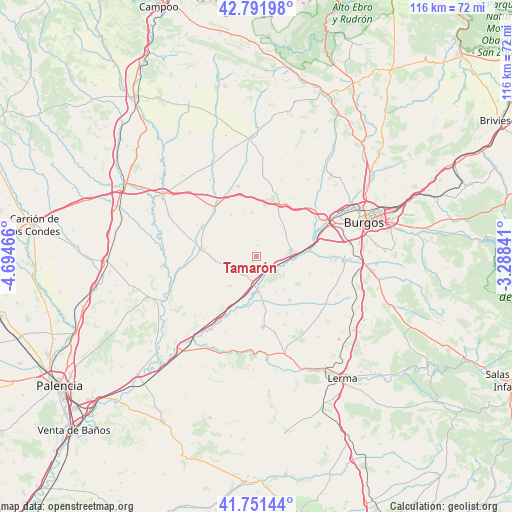
Tamarón GPS coordinates[2]
42° 16' 25.896" North, 3° 59' 29.544" West
| Map corner | latitude | longitude |
|---|---|---|
| Upper-left | 42.79198°, | -4.69466° |
| Center: | 42.27386°, | -3.99154° |
| Lower-right: | 41.75144°, | -3.28841° |
| Map W x H: | 115.7×115.7 km | = 71.9×71.9mi |
| max Lat: | 43.74134° ⇑18.8% North |
| Tamarón: | 42.27386° |
| min Lat: | ⇓81.2% South 27.64134° |
| min Long | Tamarón | max Long |
| -18.00367° | -3.99154° | 4.2899° |
| W 40.4%⇐ | ⇒59.6% E |
Elevation
Elevation of Tamarón is 821 m = 2694 ft, and this is 223 m = 732 ft above average elevation for this country.
| Max E: |
1682 m = 5518 ft | 29.1% |
| Tamarón | 821 m 2694 ft | |
| Avg. | 598 m = 1962 ft | |
Min E: |
0 m = 0 ft | 70.9% |
See also: Spain elevation on elevation.city.
Geographical zone
Tamarón is located in North temperate zone (between Tropic of Cancer and the Arctic Circle). Distance of this Northern Tropic circle is 2094.5 km =1301.5 mi to South.| Distance of | km | miles | from Tamarón |
|---|---|---|---|
| North Pole | 5306.6 | 3297.4 | to North |
| Arctic Circle | 2700.8 | 1678.2 | to North |
| Tropic Cancer | 2094.5 | 1301.5 | to South |
| Equator | 4700.4 | 2920.7 | to South |


Nearby cities:
15 places around Tamarón: (largest is in red/bold)
• Castellanos de Castro
7 km =4.3 mi,  329°
329°
• Celada del Camino
4.9 km =3 mi,  103°
103°
• Estépar
7.6 km =4.7 mi,  87°
87°
• Hontanas
6.2 km =3.9 mi,  314°
314°
• Hornillos del Camino
9 km =5.6 mi,  36°
36°
• Iglesias
2.7 km =1.7 mi,  3°
3°
• Isar
11 km =6.8 mi,  27°
27°
• Mazuela
9.5 km =5.9 mi,  141°
141°
• Olmillos de Muñó
9 km =5.6 mi,  151°
151°
• Palazuelos de Muñó
8.6 km =5.3 mi,  179°
179°
• Pampliega
7.6 km =4.7 mi, 176°
• Villaldemiro
3 km =1.9 mi,  170°
170°
• Villaquirán de la Puebla
9 km =5.6 mi,  276°
276°
• Villaquirán de los Infantes
5.3 km =3.3 mi,  195°
195°
• Villazopeque
8.6 km =5.3 mi,  193°
193°
Sources, notices
• [Note1] Compared only with cities in Spain existing in our database
• [Src1] Map data: © OpenStreetMap contributors (CC-BY-SA)
• [Src2] Other city data from geonames.org with taken over terms of usage.
• [Src3] Geographical zone / Annual Mean Temperature by Robert A. Rohde @ Wikipedia
