Isar geodata
Isar (Castille and León) is a seat of a third-order administrative division; located in Spain in Europe/Madrid (GMT+2) time zone. With population of 382 people, there are 4197 cities with bigger population in this country. Compared to other cities in Spain, 83.6% of cities are located further ↓South; 58.7% of cities are located further →East and 73.1% of cities have lower elevation than Isar. Note1


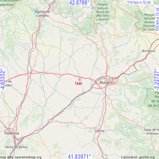
Isar GPS coordinates[2]
42° 21' 41.04" North, 3° 55' 49.44" West
| Map corner | latitude | longitude |
|---|---|---|
| Upper-left | 42.8788°, | -4.63352° |
| Center: | 42.3614°, | -3.9304° |
| Lower-right: | 41.83971°, | -3.22727° |
| Map W x H: | 115.5×115.5 km | = 71.8×71.8mi |
| max Lat: | 43.74134° ⇑16.4% North |
| Isar: | 42.3614° |
| min Lat: | ⇓83.6% South 27.64134° |
| min Long | Isar | max Long |
| -18.00367° | -3.9304° | 4.2899° |
| W 41.3%⇐ | ⇒58.7% E |
Elevation
Elevation of Isar is 836 m = 2743 ft, and this is 238 m = 781 ft above average elevation for this country.
| Max E: |
1682 m = 5518 ft | 26.9% |
| Isar | 836 m 2743 ft | |
| Avg. | 598 m = 1962 ft | |
Min E: |
0 m = 0 ft | 73.1% |
See also: Spain elevation on elevation.city.
Geographical zone
Isar is located in North temperate zone (between Tropic of Cancer and the Arctic Circle). Distance of this Northern Tropic circle is 2104.2 km =1307.5 mi to South.| Distance of | km | miles | from Isar |
|---|---|---|---|
| North Pole | 5296.9 | 3291.3 | to North |
| Arctic Circle | 2691 | 1672.1 | to North |
| Tropic Cancer | 2104.2 | 1307.5 | to South |
| Equator | 4710.1 | 2926.7 | to South |


Nearby cities:
15 places around Isar: (largest is in red/bold)
• Buniel
10.4 km =6.5 mi,  121°
121°
• Castellanos de Castro
9.3 km =5.8 mi,  246°
246°
• Celada del Camino
10.9 km =6.8 mi,  181°
181°
• Estépar
9.7 km =6 mi,  164°
164°
• Frandovínez
9.5 km =5.9 mi,  126°
126°
• Hontanas
10.9 km =6.8 mi,  240°
240°
• Hornillos del Camino
2.6 km =1.6 mi,  171°
171°
• Iglesias
8.5 km =5.3 mi,  214°
214°
• Manciles
10.7 km =6.6 mi,  353°
353°
• Pedrosa del Páramo
9.6 km =6 mi,  339°
339°
• Rabé de las Calzadas
8.2 km =5.1 mi,  106°
106°
• Sasamón
11.1 km =6.9 mi,  303°
303°
• Tamarón
11 km =6.8 mi, 207°
• Tardajos
9.4 km =5.8 mi,  98°
98°
• Villanueva de Argaño
2.1 km =1.3 mi, 353°
Sources, notices
• [Note1] Compared only with cities in Spain existing in our database
• [Src1] Map data: © OpenStreetMap contributors (CC-BY-SA)
• [Src2] Other city data from geonames.org with taken over terms of usage.
• [Src3] Geographical zone / Annual Mean Temperature by Robert A. Rohde @ Wikipedia
