Susqueda geodata
Susqueda (Catalonia) is a seat of a third-order administrative division; located in Spain in Europe/Madrid (GMT+2) time zone. With population of 115 people, there are 5757 cities with bigger population in this country. Compared to other cities in Spain, 73.1% of cities are located further ↓South; 96.6% of cities are located further ←West and 73.5% of cities have higher elevation than Susqueda. Note1


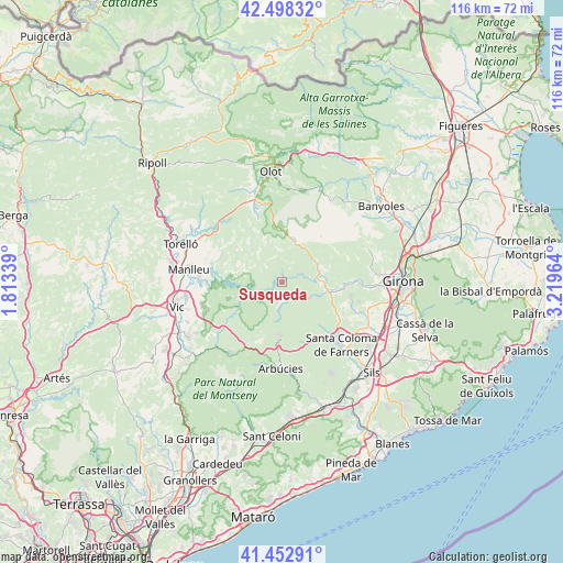
Susqueda GPS coordinates[2]
41° 58' 39.936" North, 2° 30' 59.472" East
| Map corner | latitude | longitude |
|---|---|---|
| Upper-left | 42.49832°, | 1.81339° |
| Center: | 41.97776°, | 2.51652° |
| Lower-right: | 41.45291°, | 3.21964° |
| Map W x H: | 116.2×116.2 km | = 72.2×72.2mi |
| max Lat: | 43.74134° ⇑26.9% North |
| Susqueda: | 41.97776° |
| min Lat: | ⇓73.1% South 27.64134° |
| min Long | Susqueda | max Long |
| -18.00367° | 2.51652° | 4.2899° |
| W 96.6%⇐ | ⇒3.4% E |
Elevation
Elevation of Susqueda is 324 m = 1063 ft, and this is 274 m = 899 ft below average elevation for this country.
| Max E: |
1682 m = 5518 ft | 73.5% |
| Avg. | 598 m = 1962 ft | |
| Susqueda | 324 m = 1063 ft | |
Min E: |
0 m = 0 ft | 26.5% |
See also: Spain elevation on elevation.city.
Geographical zone
Susqueda is located in North temperate zone (between Tropic of Cancer and the Arctic Circle). Distance of this Northern Tropic circle is 2061.6 km =1281 mi to South.| Distance of | km | miles | from Susqueda |
|---|---|---|---|
| North Pole | 5339.6 | 3317.9 | to North |
| Arctic Circle | 2733.7 | 1698.6 | to North |
| Tropic Cancer | 2061.6 | 1281 | to South |
| Equator | 4667.5 | 2900.2 | to South |


Nearby cities:
15 places around Susqueda: (largest is in red/bold)
• Anglès
10.2 km =6.3 mi,  103°
103°
• Arbúcies
17.9 km =11.1 mi,  179°
179°
• Brunyola
16.3 km =10.1 mi,  122°
122°
• Sant Aniol de Finestres
13.8 km =8.6 mi,  24°
24°
• Sant Esteve d'en Bas
16.4 km =10.2 mi,  342°
342°
• Sant Feliu de Pallerols
11.1 km =6.9 mi,  356°
356°
• Sant Gregori
17.9 km =11.1 mi,  88°
88°
• Sant Hilari Sacalm
10.5 km =6.5 mi, 179°
• Sant Julià de Vilatorta
17.1 km =10.6 mi,  248°
248°
• Santa Coloma de Farners
17.5 km =10.9 mi,  134°
134°
• Santa Maria de Corcó
13.8 km =8.6 mi,  296°
296°
• Tavertet
8.3 km =5.2 mi,  283°
283°
• Vilanova de Sau
11.4 km =7.1 mi, 252°
• la Cellera de Ter
8.9 km =5.5 mi, 96°
• les Planes d'Hostoles
9 km =5.6 mi,  12°
12°
Sources, notices
• [Note1] Compared only with cities in Spain existing in our database
• [Src1] Map data: © OpenStreetMap contributors (CC-BY-SA)
• [Src2] Other city data from geonames.org with taken over terms of usage.
• [Src3] Geographical zone / Annual Mean Temperature by Robert A. Rohde @ Wikipedia
