Anglès geodata
Anglès (Catalonia) is a populated place; located in Spain in Europe/Madrid (GMT+2) time zone. With population of 5,159 people, there are 1272 cities with bigger population in this country. Compared to other cities in Spain, 72.5% of cities are located further ↓South; 96.9% of cities are located further ←West and 83.4% of cities have higher elevation than Anglès. Note1


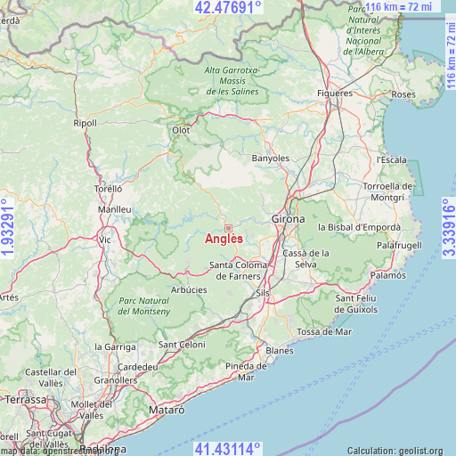
Anglès GPS coordinates[2]
41° 57' 22.212" North, 2° 38' 9.708" East
| Map corner | latitude | longitude |
|---|---|---|
| Upper-left | 42.47691°, | 1.93291° |
| Center: | 41.95617°, | 2.63603° |
| Lower-right: | 41.43114°, | 3.33916° |
| Map W x H: | 116.3×116.3 km | = 72.3×72.3mi |
| max Lat: | 43.74134° ⇑27.5% North |
| Anglès: | 41.95617° |
| min Lat: | ⇓72.5% South 27.64134° |
| min Long | Anglès | max Long |
| -18.00367° | 2.63603° | 4.2899° |
| W 96.9%⇐ | ⇒3.1% E |
Elevation
Elevation of Anglès is 163 m = 535 ft, and this is 435 m = 1427 ft below average elevation for this country.
| Max E: |
1682 m = 5518 ft | 83.4% |
| Avg. | 598 m = 1962 ft | |
| Anglès | 163 m = 535 ft | |
Min E: |
0 m = 0 ft | 16.6% |
See also: Spain elevation on elevation.city.
Geographical zone
Anglès is located in North temperate zone (between Tropic of Cancer and the Arctic Circle). Distance of this Northern Tropic circle is 2059.2 km =1279.5 mi to South.| Distance of | km | miles | from Anglès |
|---|---|---|---|
| North Pole | 5342 | 3319.4 | to North |
| Arctic Circle | 2736.1 | 1700.1 | to North |
| Tropic Cancer | 2059.2 | 1279.5 | to South |
| Equator | 4665.1 | 2898.8 | to South |


Nearby cities:
15 places around Anglès: (largest is in red/bold)
• Aiguaviva
10.6 km =6.6 mi,  100°
100°
• Bescanó
8.6 km =5.3 mi,  82°
82°
• Brunyola
7.4 km =4.6 mi,  147°
147°
• Fornells de la Selva
14.6 km =9.1 mi, 100°
• Riudellots de la Selva
15.6 km =9.7 mi,  116°
116°
• Salt
13.1 km =8.1 mi, 80°
• Sant Aniol de Finestres
15.4 km =9.6 mi,  344°
344°
• Sant Gregori
8.6 km =5.3 mi,  69°
69°
• Sant Hilari Sacalm
12.8 km =8 mi,  230°
230°
• Santa Coloma de Farners
10.3 km =6.4 mi,  165°
165°
• Susqueda
10.2 km =6.3 mi,  283°
283°
• Vilablareix
11.4 km =7.1 mi,  89°
89°
• Vilobí d'Onyar
12.4 km =7.7 mi,  130°
130°
• la Cellera de Ter
1.8 km =1.1 mi,  325°
325°
• les Planes d'Hostoles
13.7 km =8.5 mi,  324°
324°
Sources, notices
• [Note1] Compared only with cities in Spain existing in our database
• [Src1] Map data: © OpenStreetMap contributors (CC-BY-SA)
• [Src2] Other city data from geonames.org with taken over terms of usage.
• [Src3] Geographical zone / Annual Mean Temperature by Robert A. Rohde @ Wikipedia
