Brunyola geodata
Brunyola (Catalonia) is a seat of a third-order administrative division; located in Spain in Europe/Madrid (GMT+2) time zone. In our database, there are 6762 cities with bigger population. Compared to other cities in Spain, 70.9% of cities are located further ↓South; 97.1% of cities are located further ←West and 77.3% of cities have higher elevation than Brunyola. Note1


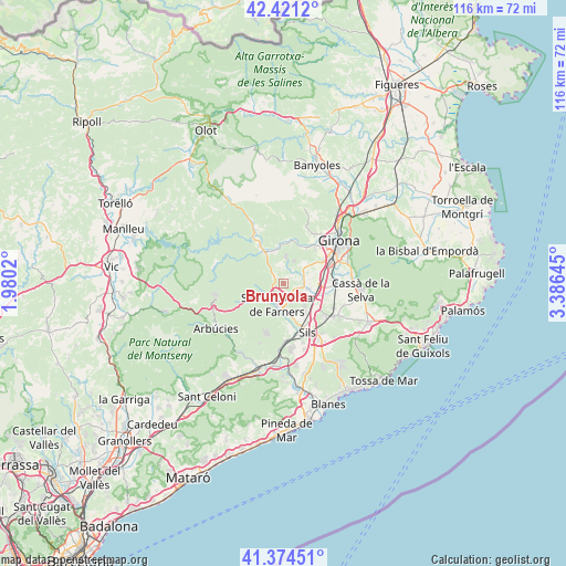
Brunyola GPS coordinates[2]
41° 54' 0" North, 2° 40' 59.988" East
| Map corner | latitude | longitude |
|---|---|---|
| Upper-left | 42.4212°, | 1.9802° |
| Center: | 41.9°, | 2.68333° |
| Lower-right: | 41.37451°, | 3.38645° |
| Map W x H: | 116.4×116.4 km | = 72.3×72.3mi |
| max Lat: | 43.74134° ⇑29.1% North |
| Brunyola: | 41.9° |
| min Lat: | ⇓70.9% South 27.64134° |
| min Long | Brunyola | max Long |
| -18.00367° | 2.68333° | 4.2899° |
| W 97.1%⇐ | ⇒2.9% E |
Elevation
Elevation of Brunyola is 265 m = 869 ft, and this is 333 m = 1093 ft below average elevation for this country.
| Max E: |
1682 m = 5518 ft | 77.3% |
| Avg. | 598 m = 1962 ft | |
| Brunyola | 265 m = 869 ft | |
Min E: |
0 m = 0 ft | 22.7% |
See also: Spain elevation on elevation.city.
Geographical zone
Brunyola is located in North temperate zone (between Tropic of Cancer and the Arctic Circle). Distance of this Northern Tropic circle is 2052.9 km =1275.6 mi to South.| Distance of | km | miles | from Brunyola |
|---|---|---|---|
| North Pole | 5348.2 | 3323.2 | to North |
| Arctic Circle | 2742.3 | 1704 | to North |
| Tropic Cancer | 2052.9 | 1275.6 | to South |
| Equator | 4658.8 | 2894.8 | to South |


Nearby cities:
15 places around Brunyola: (largest is in red/bold)
• Aiguaviva
7.8 km =4.8 mi,  56°
56°
• Anglès
7.4 km =4.6 mi,  327°
327°
• Bescanó
8.7 km =5.4 mi,  32°
32°
• Caldes de Malavella
13.3 km =8.3 mi,  123°
123°
• Fornells de la Selva
11 km =6.8 mi,  71°
71°
• Riudarenes
9.7 km =6 mi,  163°
163°
• Riudellots de la Selva
10.1 km =6.3 mi,  94°
94°
• Salt
12.3 km =7.6 mi,  47°
47°
• Sant Andreu Salou
13 km =8.1 mi,  106°
106°
• Sant Gregori
10.1 km =6.3 mi,  24°
24°
• Santa Coloma de Farners
4 km =2.5 mi,  200°
200°
• Sils
11.4 km =7.1 mi,  153°
153°
• Vilablareix
9.8 km =6.1 mi, 49°
• Vilobí d'Onyar
5.8 km =3.6 mi, 108°
• la Cellera de Ter
9.1 km =5.7 mi, 327°
Sources, notices
• [Note1] Compared only with cities in Spain existing in our database
• [Src1] Map data: © OpenStreetMap contributors (CC-BY-SA)
• [Src2] Other city data from geonames.org with taken over terms of usage.
• [Src3] Geographical zone / Annual Mean Temperature by Robert A. Rohde @ Wikipedia
