La Seu d'Urgell geodata
La Seu d'Urgell (Catalonia) is a populated place; located in Spain in Europe/Madrid (GMT+2) time zone. With population of 13,063 people, there are 702 cities with bigger population in this country. Compared to other cities in Spain, 83.6% of cities are located further ↓South; 91.7% of cities are located further ←West and 53.9% of cities have lower elevation than La Seu d'Urgell. Note1
Administrative division(s):
- Level 1: Catalonia
- Level 2: Província de Lleida
- Level 3: la Seu d'Urgell


La Seu d'Urgell GPS coordinates[2]
42° 21' 31.572" North, 1° 27' 41.184" East
| Map corner | latitude | longitude |
|---|---|---|
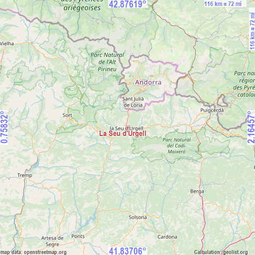
| Upper-left | 42.87619°, | 0.75832° |
| Center: | 42.35877°, | 1.46144° |
| Lower-right: | 41.83706°, | 2.16457° |
| Map W x H: | 115.5×115.5 km | = 71.8×71.8mi |
| max Lat: | 43.74134° ⇑16.4% North |
| La Seu d'Urgell: | 42.35877° |
| min Lat: | ⇓83.6% South 27.64134° |
| min Long | La Seu d'Urgell | max Long |
| -18.00367° | 1.46144° | 4.2899° |
| W 91.7%⇐ | ⇒8.3% E |
Elevation
Elevation of La Seu d'Urgell is 699 m = 2293 ft, and this is 101 m = 331 ft above average elevation for this country.
| Max E: |
1682 m = 5518 ft | 46.1% |
| La Seu d'Urgell | 699 m 2293 ft | |
| Avg. | 598 m = 1962 ft | |
Min E: |
0 m = 0 ft | 53.9% |
See also: Spain elevation on elevation.city.
Geographical zone
La Seu d'Urgell is located in North temperate zone (between Tropic of Cancer and the Arctic Circle). Distance of this Northern Tropic circle is 2103.9 km =1307.3 mi to South.| Distance of | km | miles | from La Seu d'Urgell |
|---|---|---|---|
| North Pole | 5297.2 | 3291.5 | to North |
| Arctic Circle | 2691.3 | 1672.3 | to North |
| Tropic Cancer | 2103.9 | 1307.3 | to South |
| Equator | 4709.9 | 2926.6 | to South |


Nearby cities:
15 places around La Seu d'Urgell: (largest is in red/bold)
• Alàs i Cerc
4.6 km =2.9 mi,  102°
102°
• Bellver de Cerdanya
26.5 km =16.5 mi,  88°
88°
• Coll de Nargó
23.7 km =14.7 mi,  210°
210°
• Farrera
21.8 km =13.5 mi,  314°
314°
• Ger
32.1 km =19.9 mi,  79°
79°
• Gósol
21.2 km =13.2 mi,  129°
129°
• Isòvol
29.4 km =18.3 mi, 85°
• Lles de Cerdanya
18.8 km =11.7 mi, 79°
• Meranges
28.5 km =17.7 mi,  70°
70°
• Riu de Cerdanya
30 km =18.6 mi, 92°
• Saldes
26.4 km =16.4 mi,  121°
121°
• Sort
27.8 km =17.3 mi,  282°
282°
• Toloriu
13.7 km =8.5 mi, 88°
• el Pont de Bar
11.9 km =7.4 mi, 83°
• Éller
27.9 km =17.3 mi, 76°
Sources, notices
• [Note1] Compared only with cities in Spain existing in our database
• [Src1] Map data: © OpenStreetMap contributors (CC-BY-SA)
• [Src2] Other city data from geonames.org with taken over terms of usage.
• [Src3] Geographical zone / Annual Mean Temperature by Robert A. Rohde @ Wikipedia
