Alàs i Cerc geodata
Alàs i Cerc (Catalonia) is a populated place; located in Spain in Europe/Madrid (GMT+2) time zone. With population of 1,112 people, there are 2810 cities with bigger population in this country. Compared to other cities in Spain, 83.3% of cities are located further ↓South; 91.8% of cities are located further ←West and 81.3% of cities have lower elevation than Alàs i Cerc. Note1


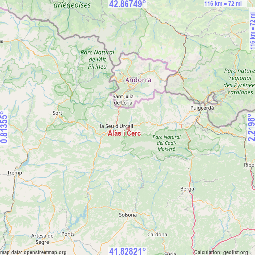
Alàs i Cerc GPS coordinates[2]
42° 21' 0" North, 1° 31' 0.012" East
| Map corner | latitude | longitude |
|---|---|---|
| Upper-left | 42.86749°, | 0.81355° |
| Center: | 42.35°, | 1.51667° |
| Lower-right: | 41.82821°, | 2.2198° |
| Map W x H: | 115.6×115.6 km | = 71.8×71.8mi |
| max Lat: | 43.74134° ⇑16.7% North |
| Alàs i Cerc: | 42.35° |
| min Lat: | ⇓83.3% South 27.64134° |
| min Long | Alàs i Cerc | max Long |
| -18.00367° | 1.51667° | 4.2899° |
| W 91.8%⇐ | ⇒8.2% E |
Elevation
Elevation of Alàs i Cerc is 910 m = 2986 ft, and this is 312 m = 1024 ft above average elevation for this country.
| Max E: |
1682 m = 5518 ft | 18.7% |
| Alàs i Cerc | 910 m 2986 ft | |
| Avg. | 598 m = 1962 ft | |
Min E: |
0 m = 0 ft | 81.3% |
See also: Spain elevation on elevation.city.
Geographical zone
Alàs i Cerc is located in North temperate zone (between Tropic of Cancer and the Arctic Circle). Distance of this Northern Tropic circle is 2103 km =1306.7 mi to South.| Distance of | km | miles | from Alàs i Cerc |
|---|---|---|---|
| North Pole | 5298.2 | 3292.1 | to North |
| Arctic Circle | 2692.3 | 1672.9 | to North |
| Tropic Cancer | 2103 | 1306.7 | to South |
| Equator | 4708.9 | 2926 | to South |


Nearby cities:
15 places around Alàs i Cerc: (largest is in red/bold)
• Bellver de Cerdanya
22 km =13.7 mi,  85°
85°
• Coll de Nargó
25.5 km =15.8 mi,  220°
220°
• Farrera
25.9 km =16.1 mi,  309°
309°
• Ger
27.8 km =17.3 mi,  75°
75°
• Gósol
17.2 km =10.7 mi,  136°
136°
• Isòvol
25 km =15.5 mi, 82°
• La Seu d'Urgell
4.6 km =2.9 mi,  282°
282°
• Lles de Cerdanya
14.7 km =9.1 mi,  72°
72°
• Meranges
24.6 km =15.3 mi,  64°
64°
• Riu de Cerdanya
25.5 km =15.8 mi, 91°
• Saldes
22 km =13.7 mi,  126°
126°
• Toloriu
9.2 km =5.7 mi, 81°
• Urús
27.7 km =17.2 mi, 89°
• el Pont de Bar
7.7 km =4.8 mi, 72°
• Éller
23.8 km =14.8 mi, 71°
Sources, notices
• [Note1] Compared only with cities in Spain existing in our database
• [Src1] Map data: © OpenStreetMap contributors (CC-BY-SA)
• [Src2] Other city data from geonames.org with taken over terms of usage.
• [Src3] Geographical zone / Annual Mean Temperature by Robert A. Rohde @ Wikipedia
