Gósol geodata
Gósol (Catalonia) is a seat of a third-order administrative division; located in Spain in Europe/Madrid (GMT+2) time zone. With population of 220 people, there are 4917 cities with bigger population in this country. Compared to other cities in Spain, 80.3% of cities are located further ↓South; 92.2% of cities are located further ←West and 99.6% of cities have lower elevation than Gósol. Note1


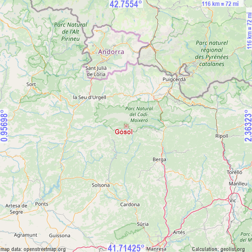
Gósol GPS coordinates[2]
42° 14' 13.092" North, 1° 39' 36.36" East
| Map corner | latitude | longitude |
|---|---|---|
| Upper-left | 42.7554°, | 0.95698° |
| Center: | 42.23697°, | 1.6601° |
| Lower-right: | 41.71425°, | 2.36323° |
| Map W x H: | 115.8×115.8 km | = 72×72mi |
| max Lat: | 43.74134° ⇑19.7% North |
| Gósol: | 42.23697° |
| min Lat: | ⇓80.3% South 27.64134° |
| min Long | Gósol | max Long |
| -18.00367° | 1.6601° | 4.2899° |
| W 92.2%⇐ | ⇒7.8% E |
Elevation
Elevation of Gósol is 1437 m = 4715 ft, and this is 839 m = 2753 ft above average elevation for this country.
| Max E: |
1682 m = 5518 ft | 0.40000000000001% |
| Gósol | 1437 m 4715 ft | |
| Avg. | 598 m = 1962 ft | |
Min E: |
0 m = 0 ft | 99.6% |
See also: Spain elevation on elevation.city.
Geographical zone
Gósol is located in North temperate zone (between Tropic of Cancer and the Arctic Circle). Distance of this Northern Tropic circle is 2090.4 km =1298.9 mi to South.| Distance of | km | miles | from Gósol |
|---|---|---|---|
| North Pole | 5310.8 | 3300 | to North |
| Arctic Circle | 2704.9 | 1680.7 | to North |
| Tropic Cancer | 2090.4 | 1298.9 | to South |
| Equator | 4696.3 | 2918.1 | to South |


Nearby cities:
15 places around Gósol: (largest is in red/bold)
• Alàs i Cerc
17.2 km =10.7 mi,  316°
316°
• Bagà
16.6 km =10.3 mi,  83°
83°
• Bellver de Cerdanya
17.6 km =10.9 mi,  35°
35°
• Capolat
19.4 km =12.1 mi,  156°
156°
• Castellar del Riu
15.8 km =9.8 mi,  143°
143°
• Guardiola de Berguedà
17.9 km =11.1 mi,  90°
90°
• Isòvol
20.3 km =12.6 mi, 39°
• Lles de Cerdanya
17.2 km =10.7 mi,  7°
7°
• Riu de Cerdanya
18.2 km =11.3 mi,  48°
48°
• Saldes
6 km =3.7 mi, 93°
• Sant Julià de Cerdanyola
19.2 km =11.9 mi, 94°
• Toloriu
14.2 km =8.8 mi,  349°
349°
• Urús
20.4 km =12.7 mi, 51°
• Vallcebre
13.5 km =8.4 mi,  105°
105°
• el Pont de Bar
15.6 km =9.7 mi,  343°
343°
Sources, notices
• [Note1] Compared only with cities in Spain existing in our database
• [Src1] Map data: © OpenStreetMap contributors (CC-BY-SA)
• [Src2] Other city data from geonames.org with taken over terms of usage.
• [Src3] Geographical zone / Annual Mean Temperature by Robert A. Rohde @ Wikipedia
